Table 6.195 — DRM_Property_Grid
Property |
Description |
||||||||||||||||||
|---|---|---|---|---|---|---|---|---|---|---|---|---|---|---|---|---|---|---|---|
|
Class |
|
||||||||||||||||||
|
Superclass |
|||||||||||||||||||
|
Subclass |
|
||||||||||||||||||
|
Definition |
An instance of this DRM class is a <DRM Data Table> instance that has at least one but not more than three spatial axes. Spatial axes shall always appear before any other <DRM Axis> components in the ordered list of <DRM Axis> components for the <DRM Property Grid> instance. A spatial axis is a <DRM Axis> component that describes sampling along one of the components of the SRF of the <DRM Property Grid> instance. Hence, it is directly useful for locating the sample values in space. To qualify as spatial, the <DRM Axis> component shall match the SRF exactly, using a consistent specification (e.g., the same ORM, direction vector and units). Spatial axes have the following characteristics.
The spatial_axis_count field specifies how many axes of the <DRM Property Grid> instance are spatial axes. The location_index field specifies up to three grid indexes that identify the grid cell that contains the location corresponding to that specified by the <DRM Location 3D> component of the <DRM Property Grid Hook Point> aggregate of the <DRM Property Grid> instance. The identified cell is where the <DRM Location 3D> instance is attached to the <DRM Property Grid> instance. The location_index shall specify a valid cell within the <DRM Property Grid> instance; that is, the indexes shall be within the appropriate bounds of the <DRM Property Grid> instance. Only the first spatial_axis_count entries of location_index are significant. The srf_context_info field specifies the SRF within which the <DRM Property Grid> instance is defined. The griddedness of spatial positions is dependent on the properties of the SRF. Coordinate conversions and transformations are not, in general, linear, so that a set of points that form a regular array of positions in one SRF may not be regular in another SRF. Therefore, in order to preserve griddedness, a <DRM Property Grid> instance specifies an SRF in which the data positions form a grid. If data_present = TRUE (the default), the <DRM Property Grid> instance contains cell values that can be extracted by invoking the appropriate API functions. Otherwise, if data_present = FALSE, the <DRM Property Grid> instance does not contain any cell values although it may provide everything else that a populated <DRM Property Grid> instance can provide. The relative_to_hook_point field specifies whether the cell data of the <DRM Property Grid> instance is specified relative to the context of a <DRM Property Grid Hook Point> instance that references it. |
||||||||||||||||||
|
Class diagram |
|||||||||||||||||||
|
Inherited field elements |
|
||||||||||||||||||
|
Field elements |
|
||||||||||||||||||
|
Default field values |
|||||||||||||||||||
Associated to (one-way) (inherited) |
|
||||||||||||||||||
Associated to (one-way) |
|
||||||||||||||||||
Associated by (one-way) (inherited) |
|
||||||||||||||||||
Associated by (one-way) |
|
||||||||||||||||||
Associated with (two-way) (inherited) |
|
||||||||||||||||||
Associated with (two-way) |
|
||||||||||||||||||
Composed of (two-way) (inherited) |
|
||||||||||||||||||
Composed of (two-way) |
|
||||||||||||||||||
Composed of (two-way metadata) (inherited) |
|
||||||||||||||||||
Composed of (two-way metadata) |
|
||||||||||||||||||
Component of (two-way) (inherited) |
|
||||||||||||||||||
Component of (two-way) |
|
||||||||||||||||||
|
Constraints |
|||||||||||||||||||
|
Clarifications |
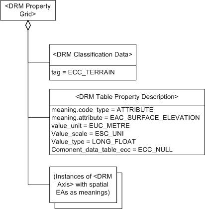
1An association between a <DRM Property Grid> instance and a <DRM Feature Representation> instance indicates that the environmental object(s) represented by the <DRM Feature Representation> instance and the <DRM Property Grid> instance (or some specific cell data within that <DRM Property Grid> instance) have the semantic relationship indicated by the <DRM Base Association Data> link object on the association relationship. Each associated <DRM Property Grid> instance indicates whether the entire <DRM Property Grid> instance or only some specific cell data within it is participating in the relationship in question. 2An association between a <DRM Property Grid> instance and a <DRM Feature Representation> instance indicates that the environmental object(s) represented by the <DRM Feature Representation> instance and the <DRM Property Grid> instance (or some specific cell data within that <DRM Property Grid> instance) have the semantic relationship indicated by the <DRM Base Association Data> link object on the association relationship. Each associated <DRM Property Grid> instance indicates whether the entire <DRM Property Grid> instance or only some specific cell data within it is participating in the relationship in question. 3The <DRM Classification Data> component indicates the kind of information represented by the <DRM Data Table> instance, such as terrain elevation or water characteristics. |
||||||||||||||||||
|
Example(s) |
|