11 Application program interface
11.1 Introduction
This International Standard specifies an API for the SRF operations in Clause 5 and Clause 10. The API specifies non-object data types (see 11.2), and object classes (see 11.3) used to perform the spatial operations. Two functions are provided to create certain object instances (see 11.4 and 11.5). Two query functions are also provided to indicate the extent of support of an API implementation for a profile of the SRM (see 11.6 and Clause 12). The API also specifies data storage structures for the representation of SRM concepts that are not used to perform spatial operations (see 11.9).
Class is the term used to categorize the general form of object instances. Each class definition specifies the methods (if any) that operate on the object. Methods are specified by giving their syntax (input and output parameters), semantics (how the inputs interact with the state of an instance of the class and produce any outputs), and error conditions. In particular, the state of an instance of the class is implicitly an input for each of its methods with the exception of the Create method. The Create method of an object depends only on its explicit inputs. The state of a class instance may change only as the result of applying a method of the class.
The active objects created as instances of a given class are reliably denoted by object references. Once created, objects exist and respond to method invocations until they are destroyed. The property of being created and existing until destruction is termed the object life cycle. Classes inherit methods from other classes through the subclass/superclass relationship. Method inheritance is transitive: a subclass also inherits the methods that have been inherited by its superclass.
Non-object data types do not have an object life cycle nor do they have operations other than those defined by a programming language that this API might be bound to.
EXAMPLE Integer is a non-object data type. Programming languages to which this API may be bound have definition mechanisms and operations for creating and then performing arithmetic operations on integers as variables and/or constants in the programming language.
The API specifies seven abstract classes (see 11.3.3 and 11.3.5):
a) LifeCycleObject,
b) BaseSRF,
c) BaseSRF2D,
d) BaseSRF3D,
e) BaseSRFwithTangentPlaneSurface,
f) BaseSRFwithEllipsoidalHeight, and
These abstract classes are used as base classes from which subclasses including concrete classes inherit common sets of methods. LifeCycleObject includes the creation and destruction methods that all other classes inherit. The LifeCycleObject creation method specification may be overridden in a concrete subclass to provide subclass specific inputs and error conditions. The use of abstract classes in this International Specification is solely for the purpose of specifying common methods in only one place instead of repeating the same specification in each concrete class for which it applies. API implementations are not required to implement abstract classes.
The API specifies six classes whose methods are not exposed as part of the API:
a) three coordinate classes: Coordinate2D, Coordinate3D, and SurfaceCoordinate;
b) one direction class Direction and
c) two position classes: Position2D, and Position3D.
These classes are private classes that hide all aspects of the implementation of instances of these objects from the application.
The API specifies a set of concrete classes that correspond to specific SRFTs specified in Clause 8 (see 11.3.6 through 11.3.10). An instance of one of these concrete classes corresponds to a specific SRF.
Instances of concrete SRF classes that correspond to the coded collection of SRFT instances specified in Table 8.30 are created by a function. This function CreateStandardSRF is a function of the corresponding SRF_Code (see 11.4).
Instances of concrete SRF classes that correspond to the members of SRF Sets specified in Table 8.31 are also created by a function. This function CreateSRFSetMember is a function of that takes as an input the SRFS_Code_Info (see 11.5).
The class hierarchy is illustrated in Figure 11.1. Procedural rules for using LifeCycleObjects in applications and examples of use of the API are provided in 11.8.
11.2 Non-object data types
11.2.1 Overview
Basic non-object data types represent single pieces of information such as numbers, codes, and other individual data items. Structured data types represent data records of basic non-object data types.
11.2.2 Abbreviations
Table 11.1 lists the SRFTs and their abbreviations used in the formation of enumerant names and record element names of non-object types.
Table 11.1 — SRFT abbreviations
|
Abbreviation |
SRFT |
|
CC |
Celestiocentric |
|
CD |
Celestiodetic |
|
CM |
Celestiomagnetic |
|
EC |
Equidistant Cylindrical |
|
EI |
Equatorial Inertial |
|
HAEC |
Heliospheric Aries Ecliptic |
|
HEEC |
Heliospheric Earth Ecliptic |
|
HEEQ |
Heliospheric Earth Equatorial |
|
LCC |
Lambert Conformal Conic |
|
LCE_3D |
Lococentric Euclidean 3D |
|
LSA |
Local Space Azimuthal |
|
LSP |
Local Space Polar |
|
LSR_2D |
Local Space Rectangular 2D |
|
LSR_3D |
Local Space Rectangular 3D |
|
LTSAS |
Local Tangent Space Azimuthal Spherical |
|
LTSC |
Local Tangent Space Cylindrical |
|
LTSE |
Local Tangent Space Euclidean |
|
M |
Mercator |
|
OMS |
Oblique Mercator Spherical |
|
PD |
Planetodetic |
|
PS |
Polar Stereographic |
|
SEC |
Solar Ecliptic |
|
SEQ |
Solar Equatorial |
|
SMD |
Solar Magnetic Dipole |
|
SME |
Solar Magnetic Ecliptic |
|
TM |
Transverse Mercator |
11.2.3 Numbers
Two categories of numbers are specified: integer numbers and floating-point numbers. The general-purpose integer data types are Integer_Positive and Integer. All implementations that conform to this standard shall support at least the minimum ranges for values of these data types as specified in Table 11.2.
Table 11.2 — Integer data types
|
Data type |
Value range |
|
Integer_Positive |
[1, 4 294 967 295] |
|
Integer |
[-2 147 483 647, 2 147 483 647] |
Long_Float is a non-object data type defined for floating-point numbers. This data type corresponds to the double precision floating-point data type specified by IEC 60559. However, implementations on architectures that support other floating-point representations are allowed.
11.2.4 Logicals
The general-purpose logical data type is Boolean. All implementations that conform to this standard shall support this type as specified in Table 11.3.
Table 11.3 — Logical data type
|
Data type |
Values |
|
Boolean |
[ false (or 0), true (or 1) ] |
11.2.5 Object_Reference
An Object_Reference is an opaque non-object data type that allows an application to reliably access an instance of an object. Object_References may be compared for equality and tested to see if they are equal to the special value NULL_Object. If two Object_References are equal, they refer to the same object instance. If an Object_Reference is equal to the special value NULL_Object it does not reference any object instance. In all the method specifications in this clause, whenever an argument passed to or returned from a method is an object, it is an object reference that is passed.
11.2.6 Enumerated data types
11.2.6.1 Introduction
Enumerated data types are data types whose values are specified from an ordered list of names. The names are assigned numbers whose values indicate the position within the ordered list. It is these numbers that are actually manipulated by the implementation. Enumerated data types are a closed list the members of which do not change based on registration or deprecation. This clause specifies the enumerated data types within this International Standard.
11.2.6.2 Axis_Direction
This data type represents the values of the axis direction parameter(s) of the SRFTs LOCAL_SPACE_RECTANGULAR_3D and LOCAL_SPACE_RECTANGULAR_2D.
Axis_Direction ::= ( POSITIVE_PRIMARY_AXIS,
POSITIVE_SECONDARY_AXIS,
POSITIVE_TERTIARY_AXIS,
NEGATIVE_PRIMARY_AXIS,
NEGATIVE_SECONDARY_AXIS,
NEGATIVE_TERTIARY_AXIS )
11.2.6.3 Coordinate_Valid_Region
This data type represents coordinate location with respect to valid-regions (see 8.3.2.4).
Coordinate_Valid_Region ::= ( VALID,
EXTENDED_VALID,
DEFINED )
VALID denotes a coordinate that is contained in the
valid-region and in the CS domain.
EXTENDED_VALID denotes a coordinate
that is contained in the extended valid-region and in the CS domain but not in
the valid-region.
DEFINED denotes a coordinate
that is contained in the CS domain but not in the valid or the extended
valid-regions.
11.2.6.4 Interval_Type
This data type is used to specify coordinate component intervals in the SetValidRegion, SetExtendedValidRegion, GetValidRegion, and GetExtendedValidRegion methods of class BaseSRF3D and in the SetValidGeodeticRegion, SetExtendedValidGeodeticRegion, GetValidGeodeticRegion, and GetExtendedValidGeodeticRegion methods of class BaseSRFMapProjection.
Interval_Type::= ( OPEN_INTERVAL,
// The bounded open interval (a, b).
GE_LT_INTERVAL, // The bounded interval [a, b).
GT_LE_INTERVAL, // The bounded interval (a, b].
CLOSED_INTERVAL, // The bounded interval [a, b].
GT_SEMI_INTERVAL, // The unbounded interval (a, +infinity).
GE_SEMI_INTERVAL, // The unbounded interval [a, +infinity).
LT_SEMI_INTERVAL, // The unbounded interval (-infinity, b).
LE_SEMI_INTERVAL, // The unbounded interval (-infinity, b].
UNBOUNDED //
All values (-infinity, +infinity)
)
11.2.6.5 Polar_Aspect
This data type represents the values of the polar aspect parameter of SRFT POLAR_STEREOGRAPHIC.
Polar_Aspect ::= ( NORTH,
SOUTH )
11.2.7 Selection data types
11.2.7.1 Introduction
Selection data types are similar to enumerated data types but form a set of entries that may be extended. Selection data types are all defined to be as distinct sub-data types of the numeric of data type Integer, but with specific meanings attached to each value. The set of selections may be augmented by assigning meanings to additional values. Selection data types are otherwise processed in the same manner as enumerated data types. The integer codes are unique within each concept set, but not between sets. Although the RT_Code is used in combination with an ORM_Code, its code space follows the general rule and is independent of the ORM_Code.
In each code space the valid Integer values are 0 and greater. Negative code values are implementation dependent and non-conforming. In each code space, the Integer value 0 (UNSPECIFIED) is reserved. Some API methods and functions allow 0 (UNSPECIFIED) as an input Integer code value and/or an output Integer code value. The valid use of 0 (UNSPECIFIED) is defined in the specification of the appropriate method or function.
11.2.7.2 CS_Code
The Integer code data type CS_Code specifies a CS by its code as defined in Clause 5 or by registration. Table 5.7 is a directory of CS specifications, each of which includes a code value and a corresponding label.
11.2.7.3 DSS_Code
The Integer code data type DSS_Code specifies an DSS by its code as defined Table 9.2 and Table J.20 or by registration. Each DSS specification includes a code value and a corresponding label.
11.2.7.4 ORM_Code
The Integer code data type ORM_Code specifies an ORM by its code as defined in Annex E and Annex J or by registration. Each ORM specification includes a code value and a corresponding label (see Clause 7).
11.2.7.5 ORMT_Code
The Integer code data type ORMT_Code specifies an ORM Template code defined in Clause 7 or by registration. Table 7.12 is a directory of ORMT specifications, each of which includes a code value and a corresponding label.
11.2.7.6 RT_Code
The Integer code data type RT_Code specifies a reference transformation HSR. Each RT_Code is defined in Annex E in the entry for the ORM or by registration, specified by the ORM_Code value, with which it is associated. Each reference transformation specification associated with an ORM includes a code value and a corresponding label.
API methods or functions that require the RT_Code data type shall also require its associated ORM_Code.
11.2.7.7 SRF_Code
The Integer code data type SRF_Code specifies an SRF by its code as defined in Table 8.30 or by registration. Each SRF specification includes a code value and a corresponding label (see Clause 8).
11.2.7.8 SRFS_Code
The Integer code data type SRFS_Code specifies an SRF set by its code as defined in Table 8.48 or by registration. Each SRF set specification includes a code value and a corresponding label (see Clause 8).
SRFS_Code ::= ( < 0 : // implementation_dependent,
0 : SRFS_UNSPECIFIED,
1 : SRFS_ALABAMA_SPCS,
2 : SRFS_GTRS_GLOBAL_COORDINATE_SYSTEM,
3 : SRFS_JAPAN_RECTANGULAR_PLANE_CS,
4 : SRFS_LAMBERT_NTF,
5 : SRFS_UNIVERSAL_POLAR_STEREOGRAPHIC,
6 : SRFS_UNIVERSAL_TRANSVERSE_MERCATOR,
7 : SRFS_WISCONSIN_SPCS,
>7 : // reserved for registration )
11.2.7.9 SRFS member types
11.2.7.9.1 Introduction
The Integer code types that specify the SRFS members associated with the SRFS defined in Table 8.48.
11.2.7.9.2 SRFSM_Alabama_SPCS_Code
The Integer code data type SRFSM_Alabama_SPCS_Code specifies a member of the Alabama SPCS SRFS in Table 8.50 or by registration.
11.2.7.9.3 SRFSM_GTRS_Global_Coordinate_System _Code
The Integer code data type SRFSM_GTRS_Global_Coordinate_System_Code specifies a member of the GTRS Global Coordinate System SRFS in Table 8.52 and Table 8.53 or by registration.
11.2.7.9.4 SRFSM_Japan_Rectangular_Plane_CS_Code
The Integer code data type SRFSM_Japan_Rectangular_Plane_CS_Code specifies a member of the Japan Rectangular Plane CS SRFS in Table 8.55 or by registration.
11.2.7.9.5 SRFSM_Lambert_NTF_Code
The Integer code data type SRFSM_Lambert_NTF_Code specifies a member of the Lambert NTF SRFS in Table 8.57 or by registration.
11.2.7.9.6 SRFSM_Universal_Polar_Stereographic_Code
The Integer code data type SRFSM_Universal_Polar_Stereographic_Code specifies a member of the Universal Polar Stereographic SRFS in Table 8.59 or by registration.
11.2.7.9.7 SRFSM_Universal_Transverse_Mercator_Code
The Integer code data type SRFSM_Universal_Transverse_Mercator_Code specifies a member of the Universal Transverse Mercator SRFS in Table 8.61 or by registration.
11.2.7.9.8 SRFSM_Wisconsin_SPCS _Code
The Integer code data type SRFSM_Wisconsin_SPCS_Code specifies a member of the Wisconsin SPCS SRFS Table 8.63 or by registration.
11.2.7.10 SRFT_Code
The Integer code data type SRFT_Code specifies an SRFT by its code as defined in Clause 8 or by registration. Table 8.3 is a directory of SRFT specifications. Each SRFT specification includes a code value and a corresponding label.
11.2.7.11 Status_Code
The Status_Code non-object selection data type specifies the status codes associated with methods on instances of classes specified in this International Standard. The meaning of values other than SUCCESS varies according to the class and method or function and is further defined in the “Error conditions” field of each method or function specification in Table 11.6 through Table 11.48 (see common error conditions in 11.3.2). This selection data type may be extended in a language binding specification.
Status_Code ::= ( < 0 : // implementation_dependent,
0 : // reserved
1 : SUCCESS, // the operation was performed successfully
2 : INVALID_SRF,
3 : INVALID_SOURCE_SRF,
4 : INVALID_SOURCE_COORDINATE,
5 : INVALID_TARGET_COORDINATE,
6 : INVALID_POINT1_COORDINATE,
7 : INVALID_POINT2_COORDINATE,
8 : OPERATION_UNSUPPORTED,
9 : INVALID_SOURCE_DIRECTION,
10 : INVALID_TARGET_DIRECTION,
11 : INVALID_CODE,
12 : INVALID_INPUT,
13 : CREATION_FAILURE,
14 : DESTRUCTION_FAILURE,
15 : FLOATING_OVERFLOW,
16 : FLOATING_UNDERFLOW,
17 : FLOATING_POINT_ERROR,
18 : MEMORY_ALLOCATION_ERROR,
>18 : // reserved for language binding specification )
11.2.8 Array data types
11.2.8.1 Introduction
Array data types specify an ordered set whose elements may be of any single data type. The index of the first element in the array is either “0” or “1” depending on the language binding. Table 11.4 specifies the notation for Array data types.
Table 11.4 — Array data type notation
|
Data type |
Notation |
|
One-dimensional array |
Data_Type_Name[ length ] |
The symbol “length” is a positive integer that specifies the length of the array. When the length is specified by another field of a record data type or by a function parameter, the field name or function parameter name will be used to indicate that the size of the array is obtained from the value of that construct.
11.2.8.2 Coordinate2D_Array
This data type specifies an array of Coordinate2D objects.
Coordinate2D_Array ::= {
length Integer_Positive;
coordinate2D_array Object_Reference [ length ];
}
11.2.8.3 Coordinate3D_Array
This data type specifies an array of Coordinate3D objects.
Coordinate3D_Array ::= {
length Integer_Positive;
coordinate3D_array Object_Reference [ length ];
}
11.2.8.4 Coordinate_Valid_Region_Array
This data type specifies an array of Coordinate_Valid_Region variables.
Coordinate_Valid_Region_Array ::= {
length Integer_Positive;
valid_region_array Coordinate_Valid_Region[ length ];
}
11.2.8.5 Direction_Array
This data type specifies an array of Direction objects.
Direction_Array ::= {
length Integer_Positive;
direction_array Object_Reference [ length ];
}
11.2.8.6 Vector_3D
This data type specifies an array of three Long_Float variables representing a vector in 3D Euclidean space.
Vector_3D ::= Long_Float[ 3 ]
11.2.9 Structured data types
11.2.9.1 Introduction
Non-object data types created as records whose elements are basic non-object data types are called structured non-object data types. This International Standard specifies a set of structured non-object data types to collect the (non-ORM) parameters needed to specify an SRF by means of an SRF template, and to collect parameters needed to specify an ORM transformation.
The following notation is used for defining the variant record data structures for non-object types:
<Variant_Record_Data_Type> ::= ( <Selector_Name> <Selection_Data_Type> )
{
<Variable_Name> <Variable_Data_Type>
<Variable_Name> <Variable_Data_Type>
…
[
<Selection_Name> : <Variable_Name> <Variable_Data_Type>;
<Selection_Name> : <Variable_Name> <Variable_Data_Type>;
…
]
}
Where:
<Variant_Record_Data_Type>: The variant record data type that is being defined.
<Selector_Name>: The name of the selector
<Selector_Data_Type>: The selection data type used to select the content of the variant record.
<Variable_Name>: The name of a record element.
<Variable_Data_Type>: The data type of a record element. Data type “<empty>” signifies the element is not present in the record.
<Selection_Name>: A selection data type enumerant for which a record element applies.
{}: The body of the variant record.
[]: The variant part of the variant record.
11.2.9.2 SRFT parameters
11.2.9.2.1 EC_Parameters
This non-object data type specifies the parameters that correspond to SRFT EQUIDISTANT_CYLINDRICAL.
EC_Parameters ::= {
origin_longitude Long_Float;
central_scale Long_Float;
false_easting Long_Float;
false_northing Long_Float;
}
11.2.9.2.2 LCC_Parameters
This non-object data type specifies the parameters that correspond to SRFT LAMBERT_CONFORMAL_CONIC.
LCC_Parameters ::= {
origin_longitude Long_Float;
origin_latitude Long_Float;
latitude1 Long_Float;
latitude2 Long_Float;
false_easting Long_Float;
false_northing Long_Float;
}
11.2.9.2.3 LSR_2D_Parameters
This non-object data type specifies the parameters that correspond to SRFT LOCAL_SPACE_RECTANGULAR_2D.
LSR_2D_Parameters ::= {
forward_direction Axis_Direction;
}
11.2.9.2.4 LSR_3D_Parameters
This non-object data type specifies the parameters that correspond to SRFT LOCAL_SPACE_RECTANGULAR_3D.
LSR_3D_Parameters ::= {
forward_direction Axis_Direction;
up_direction Axis_Direction;
}
11.2.9.2.5 Local_Tangent_Parameters
This non-object data type specifies the parameters that correspond to SRFT LOCAL_TANGENT_SPACE_AZIMUTHAL_SPHERICAL, and SRFT LOCAL_TANGENT_SPACE_CYLINDRICAL.
Local_Tangent_Parameters ::={
geodetic_longitude Long_Float;
geodetic_latitude Long_Float;
azimuth Long_Float;
height_offset Long_Float;
}
11.2.9.2.6 LTSE_Parameters
This non-object data type specifies the parameters that correspond to SRFT LOCAL_TANGENT_SPACE_EUCLIDEAN.
LTSE_Parameters ::={
geodetic_longitude Long_Float;
geodetic_latitude Long_Float;
azimuth Long_Float;
x_false_origin Long_Float;
y_false_origin Long_Float;
height_offset Long_Float;
}
11.2.9.2.7 LCE_3D_Parameters
This non-object data type specifies the parameters that correspond to SRFT LOCOCENTRIC_EUCLIDEAN_3D.
LCE_3D_Parameters ::= {
lococentre Vector_3D;
primary_axis Vector_3D;
secondary_axis Vector_3D;
}
11.2.9.2.8 M_Parameters
This non-object data type specifies the parameters that correspond to SRFT MERCATOR.
M_Parameters ::= {
origin_longitude Long_Float;
central_scale Long_Float;
false_easting Long_Float;
false_northing Long_Float;
}
11.2.9.2.9 Oblique_Mercator_Parameters
This non-object data type specifies the parameters that correspond to SRFT OBLIQUE_MERCATOR_SPHERICAL.
Oblique_Mercator_Parameters ::= {
longitude1 Long_Float;
latitude1 Long_Float;
longitude2 Long_Float;
latitude2 Long_Float;
central_scale Long_Float;
false_easting Long_Float;
false_northing Long_Float;
}
11.2.9.2.10 PS_Parameters
This non-object data type specifies the parameters that correspond to SRFT POLAR_STEREOGRAPHIC.
PS_Parameters ::= {
polar_aspect Polar_Aspect;
origin_longitude Long_Float;
central_scale Long_Float;
false_easting Long_Float;
false_northing Long_Float;
}
11.2.9.2.11 SRFS_Code_Info
This Variant_Record_Data_Type specifies an arbitrary SRFS_Code with its associated SRFS member code. The record element SRFSM_unspecified shall be set to zero (unspecified) when the selector value is SRFS_UNDEFINED.
SRFS_Code_Info ::= ( srfs_code SRFS_Code
)
{
[
SRFS_UNSPECIFIED:
SRFSM_unspecified Integer;
SRFS_ALABAMA_SPCS:
SRFSM_alabama_spcs SRFSM_Alabama_SPCS_Code;
SRFS_GTRS_GLOBAL_COORDINATE_SYSTEM:
SRFSM_gtrs_global_coordinate_system
SRFSM_GTRS_Global_Coordinate_System_Code;
SRFS_JAPAN_RECTANGULAR_PLANE_CS:
SRFSM_japan_rectangular_plane_cs
SRFSM_Japan_Rectangular_Plane_CS_Code;
SRFS_LAMBERT_NTF:
SRFSM_lambert_ntf SRFSM_Lambert_NTF_Code;
SRFS_UNIVERSAL_POLAR_STEREOGRAPHIC:
SRFSM_universal_polar_stereographic SRFSM_Universal_Polar_Stereographic_Code;
SRFS_UNIVERSAL_TRANSVERSE_MERCATOR:
SRFSM_universal_transverse_mercator SRFSM_Universal_Transverse_Mercator_Code;
SRFS_WISCONSIN_SPCS:
SRFSM_wisconsin_spcs SRFSM_Wisconsin_SPCS_Code;
]
}
11.2.9.2.12 TM_Parameters
This non-object data type specifies the parameters that correspond to SRFT TRANSVERSE_MERCATOR.
TM_Parameters ::= {
origin_longitude Long_Float;
origin_latitude Long_Float;
central_scale Long_Float;
false_easting Long_Float;
false_northing Long_Float;
}
11.2.9.3 ORM transformation parameters
11.2.9.3.1 ORM_Transformation_2D_Parameters
This non-object data type represents a 2D ORM four-parameter transformation as specified in 7.3.3.
ORM_Transformation_2D_Parameters ::= {
delta_x Long_Float;
delta_y Long_Float;
omega Long_Float;
delta_s Long_Float;
}
The valid range in radians for values of omega is (-2π, 2π). The valid range for delta_s is greater than -1.
11.2.9.3.2 ORM_Transformation_3D_Parameters
This non-object data type represents a 3D ORM seven-parameter transformation as specified in 7.3.2.
ORM_Transformation_3D_Parameters ::= {
delta_x Long_Float;
delta_y Long_Float;
delta_z Long_Float;
omega_1 Long_Float;
omega_2 Long_Float;
omega_3 Long_Float;
delta_s Long_Float;
}
The valid range in radians for values omega_1, omega_2, and omega_3 is (-2π, 2π). The valid range for delta_s is greater than -1.
11.3 Object classes
11.3.1 Introduction
SRF objects specify methods that implement the spatial operations specified in Clause 10. To aid in specification, most of the functionality of the API is defined using a class hierarchy with each abstract class providing the specification of those methods that are common to each of its subclasses. The remaining functionality is provided in concrete class and function specifications. The implementation of abstract classes is not required.
The functionality of the methods are specified in the class specification tables (see 11.3.2) that provide the method name, the semantics, inputs and outputs of the method, and the error conditions of the method. These methods manipulate internal data (object state) and any input parameters passed in. The success condition is a nominal behaviour of all methods and is not listed within the error conditions field. The success condition is associated with Status_Code SUCCESS.
EXAMPLE 1 In Table 11.13, the phrase “this SRF” refers to the internal state of an instance of a concrete class subclassed (directly or indirectly) from the abstract class specified in the table. In particular, the abstract method GetORMCode “Outputs the ORM_Code and the RT_Code of this SRF”, and shows “Inputs: none”.
Language bindings may add additional error conditions and related binding-specific mechanisms including the passing of inputs and outputs, and the presentation of method status. Language bindings shall specify these mechanisms, since this International Standard does not restrict such mechanisms. Under an error condition, output values are undefined. When several error conditions apply to a method invocation, the first error condition detected by an implementation shall be presented as the method status. The error conditions applicable to a method invocation are the common error conditions specified in 11.3.2 and the additional error conditions specified in the class specification table for the method and any language-binding specific error conditions applicable to the method.
A language binding mechanism for presentation of method status shall support the association of a unique error Status_Code (11.2.7.11)
EXAMPLE 2 If a language binding supports exception handling and if a language binding uses that mechanism to present method failure, then an exception object method that returns the corresponding Status_Code would satisfy this requirement.
11.3.2 Class specification format
Class data types are specified in tables in Table 11.5 through Table 11.44 with the following elements:
Table 11.5 — Class specification elements
|
Element |
Definition |
||
|
Class |
The name of the object class. |
||
|
Description |
The corresponding SRM concept. |
||
|
Superclass(es) |
The specification of inherited functionality listing the superclasses of the class in hierarchical order. Each superclass name is followed by a list of the methods it specifies. The method list excludes methods that are overridden. |
||
|
Method or Abstract method or Private method |
The name of the method. |
||
|
Semantics |
The specification of the method functionality. |
||
|
Inputs |
The specification(s) of the method input parameters, or "none". The state of the invoking object is implicitly an input and is not additionally listed in this field. The Create method of an object class is an exception. The Create method of an object class depends only on its explicit input parameters. |
||
|
Outputs |
The specification(s) of the method output parameters, or “none”. |
||
|
Error conditions |
The list of Status_Code values that coorespond to error conditions. Each listed value specifies the condition for which it is applicable. Common error conditions (see below) are not listed in this field. The “success condition” is not listed in this field. |
The method field of a concrete class is labelled “Method”. The method field of an abstract class is labelled “Abstract method” or “Private method”. A private method is used to document the functionality of other methods. A subclass inherits all the abstract methods of its superclass including methods that the superclass has inherited. In particular, an abstract method inherited by a concrete class shall be implemented for the concrete class. An implementation may implement private methods in concrete classes for internal use, but public access to a concrete implementation of a private method is not a requirement. The order in which the methods are listed in each class follows a life cycle pattern, i.e., creation methods, then data manipulation methods, and then spatial operations.
The Error conditions field of a method specification does not separately list the following common error conditions.
a) INVALID_SRF if the SRF object invoking the method was not successfully initialized by the API or is invalid. The condition does not apply to create methods.
b) FLOATING_OVERFLOW if a floating-point overflow error occurred in the performance of the method.
c) FLOATING_UNDERFLOW if a floating-point underflow error occurred in the performance of the method.
d) FLOATING_POINT_ERROR if a floating-point error (other than an overflow or underflow error) occurred in the performance of the method.
e) MEMORY_ALLOCATION_ERROR if a memory allocation error occurred in the performance of the method.
f) INVALID_INPUT if a Long_Float input is positive or negative infinity, or a not-a-number (NAN) value. If additional conditions apply, they are listed with this Status_Code in the (abstract/private) method Error conditions field.
11.3.3 LifeCycleObject
The LifeCycleObject class is the most basic abstract class from which all other classes inherit. LifeCycleObject is an abstract class. All other abstract classes are defined in 11.3.5.
|
Element |
Specification |
||||||
|
Class |
LifeCycleObject |
||||||
|
Description |
This is the most basic abstract class from which all other classes inherit. An object derived from a concrete subclass of LifeCycleObject is invalid until the Create method is successfully invoked. A valid object is invalid after the Destroy method is invoked. |
||||||
|
Superclass |
None, this is a top level object. Element |
||||||
|
Abstract method |
Create |
||||||
|
Semantics |
This method creates an instance of a concrete class. An implementation may perform memory allocation and/or object initialization as part of this method. |
||||||
|
Inputs |
Specific inputs are specified in concrete classes that are directly or indirectly subclassed from this class data type. |
||||||
|
Outputs |
object_reference: Object_Reference |
||||||
|
Error conditions |
CREATION_FAILURE if the object instance could not be created. |
||||||
|
Abstract method |
Destroy |
||||||
|
Semantics |
This method destroys an instance of a concrete class. An implementation may perform memory deallocation and/or object finalization as part of this method. |
||||||
|
Inputs |
object_reference: Object_Reference |
||||||
|
Outputs |
none | ||||||
|
Error conditions |
DESTRUCTION_FAILURE if the object was not successfully deallocated. |
11.3.4 Private objects
11.3.4.1 Introduction
Private object classes are concrete classes that represent objects whose methods and attributes are not exposed to the API user. Instances of these objects may be created and destroyed by methods on other objects specified in the API. Object references for instances of private objects may be passed to and returned from methods. This allows an implementation of the API to store data that can be maintained for these private object classes in whatever form is convenient for the implementation.
11.3.4.2 Coordinate3D
The Coordinate3D class represents a coordinate of CS data type 3D. It specifies no additional public methods.
|
Element |
Specification |
||
|
Class |
Coordinate3D |
||
|
Description |
A coordinate of CS data type 3D (see 5.3). |
||
|
Superclass |
LifeCycleObject: Create, Destroy |
11.3.4.3 Coordinate2D
The Coordinate2D class represents a coordinate of CS data type 2D. It specifies no additional public methods.
|
Element |
Specification |
||
|
Class |
Coordinate2D |
||
|
Description |
A coordinate of CS data type 2D (see 5.3). |
||
|
Superclass |
LifeCycleObject: Create, Destroy |
11.3.4.4 SurfaceCoordinate
The SurfaceCoordinate class represents a coordinate of CS data type surface. It specifies no additional public methods.
Table 11.9 — SurfaceCoordinate
|
Element |
Specification |
|
Class |
SurfaceCoordinate |
|
Description |
A coordinate of CS data type surface (see 5.5.2.). |
|
Superclass |
LifeCycleObject: Create, Destroy |
11.3.4.5 Direction
The Direction class represents the reference coordinate corresponding to the reference position and the normal vector of a direction in a 3D object-space. It specifies no additional public methods.
|
Element |
Specification |
|
Class |
Direction |
|
Description |
A direction (see 10.5.2). |
|
Superclass |
LifeCycleObject: Create, Destroy |
11.3.4.6 Position3D
The Position3D class represents a point in a 3D position-space. It specifies no additional public methods. It is the input or output of some private methods of the BaseSRF3D class.
|
Element |
Specification |
|
Class |
Position3D |
|
Description |
A point in a 3D position-space |
|
Superclass |
LifeCycleObject: Create, Destroy |
11.3.4.7 Position2D
The Position2D class represents a point in a 2D position-space. It specifies no additional public methods. It is the input or output of some private methods of the BaseSRF2D class.
|
Element |
Specification |
|
Class |
Position2D |
|
Description |
A point in a 2D position-space |
|
Superclass |
LifeCycleObject: Create, Destroy |
11.3.5 Abstract classes
11.3.5.1 BaseSRF
This is the base class for all SRF classes. BaseSRF provides common methods to return coded values that may be associated with an SRF class instance.
|
Element |
Specification |
|||
|
Class |
BaseSRF |
|||
|
Description |
An abstract class specifying the common methods of all SRF classes |
|||
|
Superclass |
LifeCycleObject: Create, Destroy |
|||
|
Abstract method |
GetORMCodes |
|||
|
Semantics |
Outputs the ORM_Code and the RT_Code of this SRF. |
|||
|
Inputs |
none |
|||
|
Outputs |
orm_code: ORM_Code rt_code: RT_Code |
|
||
|
Error conditions |
No additional error conditions. (See 11.3.2.) |
|||
|
Abstract method |
GetSRFCodes |
|
||
|
Semantics |
1) Outputs the SRFT_Code of this SRF class instance. 2) If created by the CreateStandardSRF function, outputs a valid SRF_Code (otherwise output 0). See 11.4. 3) If created by the CreateSRFSetMember function, outputs a valid SRFS_Code_Info (otherwise outputs the SRFS_Code_Info with SRFS_Code selector value set to SRFS_UNSPECIFIED). See 11.5. |
|||
|
Inputs |
none |
|||
|
Outputs |
srft_code: SRFT_Code |
|||
|
Error conditions |
No additional error conditions. (See 11.3.2.) |
|||
|
Abstract method |
GetCSCode | |||
|
Semantics |
Outputs the CS_Code code of this SRF. |
|||
|
Inputs |
none |
|||
|
Outputs |
cs_code: CS_Code | |||
|
Error conditions |
No additional error conditions. (See 11.3.2.) |
|||
11.3.5.2 BaseSRF2D
This is the base class for all 2D SRF classes. BaseSRF2D is a subclass of BaseSRF. This abstract class adds the following methods:
CreateCoordinate2D,
GetCoordinate2DValues,
ChangeCoordinate2DSRF,
ChangeCoordinate2DSRFObject,
ChangeCoordinate2DArraySRF,
ChangeCoordinate2DArraySRFObject, and
EuclideanDistance.
These methods, respectively, create a Coordinate2D, query component values of an exiting Coordinate2D, change Coordinate2D representation from some other 2D SRF instance, change an array of Coordinate2D representation from some other 2D SRF instance, or compute the Euclidean distance between coordinates.
The ChangeCoordinate2DSRF method is for the case of source and target SRF instances based on object-fixed ORMs for the same spatial object using the methodology of 10.4.2 and the ORM reference transformations specified by the RT_Code input to the concrete SRF Create method. The method ChangeCoordinate2DSRFObject is for the general case of any pair of instances of concrete SRFs subclassed from BaseSRF2D where the ORM transformation HST is explicitly specified with an input ORM_Transformation_2D_Parameters data structure. The ChangeCoordinate2DArraySRF and the ChangeCoordinate2DArraySRFObject methods are similar to the above operating on arrays of spatial objects.
BaseSRF2D also adds the private methods Generating2D and InverseGenerating2D that are used to specify the functionality of the ChangeCoordinate2DSRF, and ChangeCoordinate2DSRFObject methods.
|
Element |
Specification |
|
|
Class |
BaseSRF2D |
|
|
Description |
An abstract class representing the common elements of concrete SRF classes that have a coordinate system of CS data type 2D. |
|
|
Superclasses |
LifeCycleObject: Create, Destroy BaseSRF: GetORMCodes, GetSRFCodes, GetCSCode |
|
|
Abstract method |
CreateCoordinate2D |
|
|
Semantics |
This method accepts the two ordered coordinate components and for a specific SRF concrete class instance creates a 2D coordinate instance initialized with the values passed in. Coordinate components that represent lengths shall be evaluated in metres. Coordinate components that represent angles shall be evaluated in radians. | |
|
Inputs |
first_coordinate_component: Long_Float second_coordinate_component: Long_Float | |
|
Outputs |
new_coordinate: Coordinate2D | |
|
Error conditions |
INVALID_INPUT if the coordinate values are not in the accuracy domain of this SRF. | |
|
Abstract method |
GetCoordinate2DValues | |
|
Semantics |
This method retrieves the two ordered coordinate components of a 2D coordinate instance previously initialized through the API. Coordinate components that represent lengths shall be evaluated in metres. Coordinate components that represent angles shall be evaluated in radians. | |
|
Inputs |
coordinate: Coordinate2D | |
|
Outputs |
first_coordinate_component: Long_Float second_coordinate_component: Long_Float | |
|
Error conditions |
INVALID_SOURCE_COORD if the coordinate is not associated with this SRF, or not initialized through the API. | |
|
Abstract method |
ChangeCoordinate2DSRF | |
|
Semantics |
This method changes the SRF representation of the spatial position specified by the input Coordinate2D source_coordinate in the source SRF source_srf to a Coordinate2D target_coordinate in this SRF, the target SRF, in accordance with 10.4.2 using the implicit ORM transformation HST given in Equation (9). The required functionally is equivalent to: 1) apply the Generating2D method of srf_source to the input source_coordinate to obtain a source Position2D as an output, 2) apply the implicit HST to the source Position2D to obtain a target Position2D, and 3) apply the InverseGenerating2D method of this SRF to the target Position2D to obtain the target_coordinate output. | |
|
Inputs |
source_srf: BaseSRF2D source_coordinate: Coordinate2D | |
|
Outputs |
target_coordinate: Coordinate2D | |
|
Error conditions |
1) INVALID_SOURCE_COORDINATE if source_coordinate is not (1) in the accuracy domain of the source_srf, or (2) associated with the source_srf. 2) INVALID_SOURCE_SRF if source_srf was not successfully initialized through the API or is invalid. 3) INVALID_TARGET_COORDINATE if the target_coordinate is not in the accuracy domain of this SRF. | |
|
Abstract method |
ChangeCoordinate2DSRFObject | |
|
Semantics |
This method changes the SRF representation of the spatial position specified by the input Coordinate2D source_coordinate in the source SRF source_srf to a Coordinate2D target_coordinate in this SRF, the target SRF, using an explicit ORM transformation HST as specified by the H_ST input in accordance with sub-clause 10.4.2. The required functionally is equivalent to: 1) apply the Generating2D method of srf_source to the input source_coordinate to obtain a source Position2D as an output, 2) apply the explicit HST to the source Position2D to obtain a target Position2D, and 3) apply the InverseGenerating2D method of this SRF to the target Position2D to obtain the target_coordinate output. | |
|
Inputs |
source_srf: BaseSRF2D source_coordinate: Coordinate2D | |
|
Outputs |
target_coordinate: Coordinate2D | |
|
Error conditions |
1) INVALID_SOURCE_COORDINATE if source_coordinate is not (1) in the accuracy domain of the source_srf, or (2) associated with the source_srf. 2) INVALID_SOURCE_SRF if source_srf was not successfully initialized through the API or is invalid. 3) INVALID_TARGET_COORDINATE if the target_coordinate is not in the accuracy domain of this SRF. | |
|
Abstract method |
ChangeCoordinate2DArraySRF | |
|
Semantics |
This method performs the same operation defined for the ChangeCoordinate2DSRF method on each Coordinate2D object in its the source_coordinate_array. The processing is in array indexing order. Upon an error condition, the processing is halted and the output index is set to the array index of the offending coordinate. When successful, the output index is set to the size of the array plus one. | |
|
Inputs |
source_srf: BaseSRF2D source_coordinate_array: Coordinate2D_Array | |
|
Outputs |
target_coordinate_array: Coordinate2D_Array index: Integer_Positive | |
|
Error conditions |
1) INVALID_SOURCE_COORDINATE if the coordinate element index in the source_coordinate_array is not (1) in the accuracy domain of the source_srf, or (2) associated with the source_srf. 2) INVALID_SOURCE_SRF if source_srf was not successfully initialized through the API or is invalid. 3) INVALID_INPUT if the source_coordinate_array and the target_coordinate_array are not the same size. 4) INVALID_TARGET_COORDINATE if the coordinate element index in the target_coordinate_array is not (1) in the accuracy domain of this SRF, or (2) associated with this SRF. | |
|
Abstract method |
ChangeCoordinate2DArraySRFObject | |
|
Semantics |
This method performs the same operation defined for the ChangeCoordinate2DSRFObject method on each Coordinate2D object in the input source_coordinate_array. The processing is in array indexing order. Upon an error condition, the processing is halted and the output index is set to the array index of the offending coordinate. When successful, the output index is set to the size of the array plus one. | |
|
Inputs |
source_srf: BaseSRF2D source_coordinate_array: Coordinate2D_Array | |
|
Outputs |
target_coordinate_array: Coordinate2D_Array index: Integer_Positive | |
|
Error conditions |
1) INVALID_SOURCE_COORDINATE if the coordinate element index in the source_coordinate_array is not (1) in the accuracy domain of the source_srf, or (2) associated with the source_srf. 2) INVALID_SOURCE_SRF if source_srf was not successfully initialized through the API or is invalid. 3) INVALID_INPUT if the source_coordinate_array and the target_coordinate_array are not the same size, or if the H_ST is not valid. 4) INVALID_TARGET_COORDINATE if the coordinate element index in the target_coordinate_array is not (1) in the accuracy domain of this SRF, or (2) associated with this SRF. | |
|
Abstract method |
EuclideanDistance | |
|
Semantics |
Outputs the Euclidean distance in metres between the spatial points represented by Coordinate2D point1_coordinate and point2_coordinate. | |
|
Inputs |
point1_coordinate:
Coordinate2D | |
|
Outputs | distance: Long_Float | |
|
Error conditions |
1) INVALID_POINT1_COORDINATE if point1_coordinate is not in the coordinate system domain of this SRF. 2) INVALID_POINT2_COORDINATE if point2_coordinate is not in the coordinate system domain of this SRF. | |
|
Private method |
Generating2D | |
|
Semantics |
This method implements the coordinate system generating function of this SRF changing the input Coordinate2D in coordinate-space to the output Position2D in position-space as specified in 5.9. | |
|
Inputs |
coordinate: Coordinate2D | |
|
Outputs |
position: Position2D | |
|
Error conditions |
INVALID_SOURCE_COORDINATE if coordinate is not in the coordinate system domain of this SRF. | |
|
Private method |
InverseGenerating2D | |
|
Semantics |
This method implements the coordinate system inverse generating function of this SRF changing the input Position2D in position-space to the output Coordinate2D in coordinate-space as specified in 5.9. | |
|
Inputs |
position: Position2D | |
|
Outputs |
coordinate: Coordinate2D | |
|
Error conditions |
INVALID_SOURCE_COORDINATE if coordinate is not in the coordinate system domain of this SRF. | |
NOTE: The method ChangeCoordinate2DSRF semantics describes the required functionality in terms of the private methods Generating2D, and InverseGenerating2D. This computational scheme is presented only for the purpose of specifying the required functionality, and does not take into account error checking and various computational short cuts and efficiencies that an actual implementation design would consider. (Some of these efficiencies are presented in Clause 10). This remark is also applicable to the ChangeCoordinate2DSRFObject method.
11.3.5.3 BaseSRF3D
This is the base class for 3D SRF classes. BaseSRF3D is a subclass of BaseSRF. This abstract class adds the methods SetValidRegion and SetExtendedValidRegion to define coordinate valid and extended valid-regions to an SRF as in 8.3.2.4, and GetValidRegion and GetExtendedValidRegion to retrive this information.
BaseSRF3D adds the following methods:
CreateCoordinate3D,
GetCoordinate3DValues,
ChangeCoordinate3DSRF,
ChangeCoordinate3DSRFObject,
ChangeCoordinate3DArraySRF,
ChangeCoordinate3DArraySRFObject, and
EuclideanDistance.
These methods, respectively, create a Coordinate3D, query component values of an exiting Coordinate3D, change Coordinate3D representation from some other 3D SRF instance, change an array of Coordinate3D representation from some other 3D SRF instance, or compute the Euclidean distance between coordinates.
BaseSRF3D also adds the following methods:
CreateDirection,
GetDirectionValues,
ChangeDirectionSRF,
ChangeDirectionSRFObject,
ChangeDirectionArraySRF, and
ChangeDirectionArraySRFObject.
These methods, respectively, create a Direction, query component values of an exiting Direction, change Direction representation from some other 3D SRF instance, or change an array of Direction representation from some other 3D SRF instance.
The ChangeCoordinate3DSRF and ChangeDirectionSRF methods are for source and target SRF instances based on object-fixed ORMs for the same spatial object using the methodology of 10.3.1 and the ORM reference transformations specified by the RT_Code input to the concrete SRF Create method. The methods ChangeCoordinate3DSRFObject and ChangeDirectionSRFObject are for the general case of any pair of instances of concrete SRF classes subclassed from BaseSRF3D where the ORM transformation H is explicitly specified with an input ORM_Transformation_3D_Parameters data structure.
BaseSRF3D also adds the private methods Generating3D and InverseGenerating3D that are used to specify the functionality of the ChangeCoordinate3DSRF, ChangeCoordinate3DSRFObject, ChangeDirectionSRFObject, and ChangeDirectionSRF methods.
|
Element |
Specification | ||||
|
Class |
BaseSRF3D | ||||
|
Description |
An abstract class representing the common elements of concrete SRF classes that have a coordinate system of CS data type 3D. | ||||
|
Superclasses |
LifeCycleObject: Create, Destroy BaseSRF: GetORMCodes, GetSRFCodes, GetCSCode | ||||
|
Abstract method |
CreateCoordinate3D | ||||
|
Semantics |
This method creates a Coordinate3D for this SRF from three ordered coordinate component values. Coordinate components that represent lengths shall be evaluated in metres. Coordinate components that represent angles shall be evaluated in radians. | ||||
|
Inputs |
first_coordinate_component: Long_Float second_coordinate_component: Long_Float third_coordinate_component: Long_Float | ||||
|
Outputs |
new_coordinate: Coordinate3D | ||||
|
Error conditions |
INVALID_INPUT if the coordinate values are not in the accuracy domain of this SRF. | ||||
|
Abstract method |
SetValidRegion | ||||
|
Semantics |
This method creates a numeric interval for valid values of a coordinate component. (See 8.3.2.4) Given a coordinate component, the last invocation of this method or the SetExtendedValidRegion method determines the valid interval of the coordinate component values. If an extended value interval has previously been set for a coordinate component by the SetExtendedValidRegion method, the extended interval limits shall be adjusted as necessary to contain the valid interval. The input value of upper_bound_bound is ignored if type is a
semi-interval GT_SEMI_INTERVAL, or GE_SEMI_INTERVAL, or
UNBOUNDED. | ||||
|
Inputs |
component_identifier: Integer; | ||||
|
Outputs | none | ||||
|
Error conditions |
INVALID_INPUT if a) the value of component_identifier is not 1, 2, or 3, or b) the coordinate-component is not angular and the value of lower_bound is not strictly less than the value of upper_bound_bound and type is not a semi-interval or unbounded type, or c) the coordinate-component is angular and the value of type is a semi-interval type, or d) the coordinate-component is angular, the value of type is a bounded interval and the value of lower_bound or upper_bound_bound does not satisfy the corresponding CS domain constraints or the values are equal. | ||||
|
Abstract method |
SetExtendedValidRegion | ||||
|
Semantics |
This method creates numeric intervals for both valid values and extended valid values of a coordinate component. (See 8.3.2.4) Given a coordinate component, the last invocation of this method or the SetValidRegion method determines the valid and extended valid intervals of the coordinate component values. The upper_bound
and extended_upper_bound values are ignored if type is GT_SEMI_INTERVAL, or GE_SEMI_INTERVAL, or UNBOUNDED. | ||||
|
Inputs |
component_identifier: Integer | ||||
|
Outputs | none | ||||
|
Error conditions |
INVALID_INPUT if a) the value of component_identifier is not 1, 2, or 3, or b) the coordinate-component is not angular and the value of lower_bound is not strictly less than the value of upper_bound and type is not a semi-interval or unbounded type, or c) the coordinate-component is angular and the value of type is a semi-interval type, or d) the coordinate-component is angular, the value of type is a bounded interval and the value of lower_bound or upper_bound does not satisfy the corresponding CS domain constraints or the values are equal, or e) the interval determined by the values extended_lower_bound and extended_upper_bound does not contain the valid region. | ||||
|
Abstract method |
GetValidRegion | ||||
|
Semantics |
This method returns the numeric interval for valid values of a coordinate component that have been set in the last SetValidRegion or SetExtendedValidRegion method invocation for the same coordinate component. If an interval has not been set for the coordinate component, the output type shall be the Interval_Type UNBOUNDED. If the output type is GT_SEMI_INTERVAL, or GE_SEMI_INTERVAL, the output value of upper_bound shall be 0.0.
If the output type is LT_SEMI_INTERVAL, or LE_SEMI_INTERVAL, the output value of lower_bound shall be 0.0.
If the output type is UNBOUNDED, the output values of lower_bound and upper_bound shall be 0.0. | ||||
|
Inputs |
component_identifier: Integer | ||||
|
Outputs | interval_type:
Interval_Type lower_bound: Long_Float upper_bound: Long_Float | ||||
|
Error conditions |
INVALID_INPUT if the value of component_identifier is not 1, 2, or 3. | ||||
|
Abstract method |
GetExtendedValidRegion | ||||
|
Semantics |
This method returns the numeric intervals for valid and extended values of a coordinate component that have been set in the last SetValidRegion or SetExtendedValidRegion method invocation for the same coordinate component. If an interval has not been set for the coordinate component, the output type shall be the Interval_Type UNBOUNDED. If SetExtendedValidRegion has not been invoked for the coordinate component, then the output extended_lower_bound shall equal the output lower_bound and the output extended_upper_bound shall equal the output upper_bound. If the output type is GT_SEMI_INTERVAL, or GE_SEMI_INTERVAL, the output values of upper_bound and extended_upper_bound shall be 0.0.
If the output type is LT_SEMI_INTERVAL, or LE_SEMI_INTERVAL, the output values of lower_bound and extended_lower_bound shall be 0.0.
If the output type is UNBOUNDED, the output values of lower_bound, extended_lower_bound, upper_bound and extended_upper_bound shall be 0.0. | ||||
|
Inputs |
component_identifier: Integer | ||||
|
Outputs |
interval_type: Interval_Type | ||||
|
Error conditions |
INVALID_INPUT if the value of component_identifier is not 1, 2, or 3. | ||||
|
Abstract method |
CreateDirection | ||||
|
Semantics |
This method accepts a Coordinate3D and the three direction components and a reference Coordinate3D and creates a Direction instance initialized with the values passed in. The direction vector shall be normalized. | ||||
|
Inputs |
reference_coordinate: Coordinate3D first_direction_component: Long_Float second_direction_component: Long_Float third_direction_component: Long_Float | ||||
|
Output |
new_direction: Direction | ||||
|
Error conditions |
1) INVALID_SOURCE_COORD if reference_coordinate is not in the accuracy domain of this SRF. 2) INVALID_SOURCE_DIRECTION If the direction components are all zero. | ||||
|
Abstract method |
GetCoordinate3Dvalues | ||||
|
Semantics |
This method retrieves the three ordered coordinate components of a 3D coordinate instance previously initialized through the API. Coordinate components that represent lengths shall be evaluated in metres. Coordinate components that represent angles shall be evaluated in radians. | ||||
|
Inputs |
coordinate: Coordinate3D | ||||
|
Outputs |
first_coordinate_component: Long_Float second_coordinate_component: Long_Float third_coordinate_component: Long_Float | ||||
|
Error conditions |
INVALID_SOURCE_COORD if the coordinate was not a 3D coordinate for this SRF, or not initialized through the API. | ||||
|
Abstract method |
GetDirectionValues | ||||
|
Semantics |
This method retrieves the reference coordinate and the three components of a direction instance previously initialized through the API. | ||||
|
Inputs |
direction: Direction | ||||
|
Outputs |
reference_coordinate: Coordinate3D first_direction_component: Long_Float second_direction_component: Long_Float third_direction_component: Long_Float | ||||
|
Error conditions |
INVALID_SOURCE_DIRECTION if the reference coordinate was not a 3D coordinate for this SRF, or not initialized through the API. | ||||
|
Abstract method |
ChangeCoordinate3DSRF | ||||
|
Semantics |
This method changes the SRF representation of the spatial position specified by the input Coordinate3D source_coordinate in the source SRF source_srf to a Coordinate3D target_coordinate in this SRF, the target SRF, in accordance with sub-clause 10.4.2 using the implicit ORM transformation HST given in Equation (9). The required functionally is equivalent to: 1) apply the Generating3D method of srf_source to the input source_coordinate to obtain a source Position3D as an output, 2) apply the implicit HST to the source Position3D to obtain a target Position3D, and 3) apply the InverseGenerating3D method of this SRF to the target Position3D to obtain the target_coordinate and region outputs. When successful, the region output is the enumerated value DEFINED, unless a valid-region or extended valid-region has been defined in terms of coordinate intervals for this SRF using the SetValidRegion or SetExtendedValidRegion methods. In that case, the appropriate enumerated Coordinate_Valid_Region value is returned. | ||||
|
Inputs |
source_srf: Base3DSRF source_coordinate: Coordinate3D | ||||
|
Outputs |
target_coordinate: Coordinate3D region: Coordinate_Valid_Region | ||||
|
Error conditions |
1) INVALID_SOURCE_SRF if source_srf was not successfully initialized through the API or is invalid. 2) INVALID_SOURCE_COORDINATE if source_coordinate is not in the accuracy domain of the SRF specified by source_srf. 3) OPERATION_UNSUPPORTED If this SRF or the source_srf was created with reference transformation RT_Code value 0 (UNSPECIFIED), or if source_srf is an SRF for a different spatial object. 4) INVALID_TARGET_COORDINATE if the spatial position is not in the accuracy domain of this SRF. | ||||
|
Abstract method |
ChangeCoordinate3DSRFObject | ||||
|
Semantics |
This method changes the SRF representation of the spatial position specified by the input Coordinate3D source_coordinate in the source SRF source_srf to a Coordinate3D target_coordinate in this SRF, the target SRF, using an explicit ORM transformation HST as specified by the H_ST input in accordance with sub-clause 10.4.1. The required functionally is equivalent to: 1) apply the Generating3D method of srf_source to the input source_coordinate to obtain a source Position3D as an output, 2) apply the explicit HST to the source Position3D to obtain a target Position3D, and 3) apply the InverseGenerating3D method of this SRF to the target Position3D to obtain the target_coordinate and region outputs. When successful, the region output is the enumerated value DEFINED, unless a valid-region of extended valid-region has been defined in terms of coordinate intervals for this SRF. In that case, the appropriate enumerated Coordinate_Valid_Region value is returned. | ||||
|
Inputs |
source_srf: Base3DSRF source_coordinate: Coordinate3D | ||||
|
Outputs |
target_coordinate: Coordinate3D region: Coordinate_Valid_Region | ||||
|
Error conditions |
1) INVALID_SOURCE_SRF if source_srf was not successfully initialized through the API or is invalid. 2) INVALID_SOURCE_COORDINATE if source_coordinate is not in the accuracy domain of the SRF specified by source_srf. 3) INVALID_INPUT if H_ST parameter values are not in range. 4) INVALID_TARGET_COORDINATE if the spatial position is not in the accuracy domain of this SRF. | ||||
|
Abstract method |
ChangeCoordinateArray3DSRF | ||||
|
Semantics |
This method performs the same operation defined for the ChangeCoordinate3DSRF method on each Coordinate3D object in the input source_coordinate_array. The processing is in array indexing order. Upon an error condition, the processing is halted and the output index is set to the array index of the offending coordinate. When successful, the output index is set to the size of the array plus one. | ||||
|
Inputs |
source_srf: BaseSRF3D source_coordinate_array: Coordinate3D_Array | ||||
|
Outputs |
target_coordinate_array: Coordinate3D_Array index: Integer_Positive region_array: Coordinate_Valid_Region_Array | ||||
|
Error conditions |
1) INVALID_SOURCE_COORDINATE if the coordinate element index in the source_coordinate_array is not (1) in the accuracy domain of the SRF source_srf, or (2) associated with the source_srf SRF. 2) INVALID_SOURCE_SRF if source_srf was not successfully initialized through the API or is invalid. 3) INVALID_INPUT if the source_coordinate_array, the target_coordinate_array, and the region_array are not the same size. 4) OPERATION_UNSUPPORTED If this SRF or the source_srf was created with reference transformation RT_Code value 0 (UNSPECIFIED). 5) INVALID_TARGET_COORDINATE if the coordinate element index in the target_coordinate_array is not (1) in the accuracy domain of this SRF, or (2) associated with this SRF. | ||||
|
Abstract method |
ChangeCoordinate3DArraySRFObject | ||||
|
Semantics |
This method performs the same operation defined for the ChangeCoordinate3DSRFObject method on each Coordinate3D object in the input source_coordinate_array. The processing is in array indexing order. Upon an error condition, the processing is halted and the output index is set to the array index of the offending coordinate. When successful, the output index is set to the size of the array plus one. | ||||
|
Inputs |
source_srf: BaseSRF3D source_coordinate_array: Coordinate3D_Array |
||||
|
Outputs |
target_coordinate_array: Coordinate3D_Array index: Integer_Positive region_array: Coordinate_Valid_Region_Array | ||||
|
Error conditions |
1) INVALID_SOURCE_COORDINATE if the coordinate element index in the source_coordinate_array is not (1) in the accuracy domain of the SRF source_srf, or (2) associated with the source_srf SRF. 2) INVALID_SOURCE_SRF if source_srf was not successfully initialized through the API or is invalid. 3) INVALID_INPUT if the source_coordinate_array, the target_coordinate_array, and the region_array are not the same size, or if the H_ST is not valid. 4) OPERATION_UNSUPPORTED If this SRF or the source_srf was created with reference transformation RT_Code value 0 (UNSPECIFIED). 5) INVALID_TARGET_COORDINATE if the coordinate element index in the target_coordinate_array is not (1) in the accuracy domain of this SRF, or (2) associated with this SRF. | ||||
|
Abstract method |
ChangeDirectionSRF | ||||
|
Semantics |
This method changes the SRF representation of the input Direction source_direction in the source SRF source_srf to a Direction target_direction in this SRF, the target SRF, in accordance with 10.5.3 using the implicit ORM transformation HST given in Equation (9) based on the RT_Codes of the source and target SRFs. The reference_coordinate representation is changed. The change is functionally equivalent to ChangeCoordinate3DSRF. When successful, the ref_coord_region output is the enumerated value DEFINED, unless a valid-region of extended valid-region has been defined in terms of coordinate intervals for this SRF. In that case, the appropriate enumerated value is returned to correspond to the reference_coordinate component of the target_direction. | ||||
|
Inputs |
source_srf: Base3DSRF source_direction: Direction | ||||
|
Outputs |
target_direction: Direction | ||||
|
Error conditions |
1) INVALID_SOURCE_DIRECTION If the reference coordinate of the Direction is invalid or if the direction components are all zero. 2) INVALID_SOURCE_SRF, if source_srf was not successfully initialized through the API or is invalid. 3) OPERATION_UNSUPPORTED, if this SRF or the source_srf was created with reference transformation RT_Code value 0 (UNSPECIFIED), or if source_srf is an SRF for a different spatial object. 4) INVALID_SOURCE_COORDINATE, if the reference location of the direction is not in the accuracy domain of this source_srf. 5) INVALID_TARGET_COORDINATE if the reference location of the direction is not in the accuracy domain of this SRF. | ||||
|
Abstract method |
ChangeDirectionSRFObject | ||||
|
Semantics |
This method changes the SRF representation of the input Direction source_direction in the source SRF source_srf to a Direction target_direction in this SRF, the target SRF, in accordance with 10.5.3 using the rotation matrix of the explicit ORM transformation HST corresponding to the H_ST input. The reference_coordinate representation is changed. The change is functionally equivalent to ChangeCoordinate3DSRFObject. When successful, the ref_coord_region output is the enumerated value DEFINED, unless a valid-region of extended valid-region has been defined in terms of coordinate intervals for this SRF. In that case, the appropriate enumerated value is returned to correspond to the reference_coordinate component of the target_direction. | ||||
|
Inputs |
source_srf: Base3DSRF source_direction: Direction | ||||
|
Outputs |
target_direction: Direction | ||||
|
Error conditions |
1) INVALID_SOURCE_DIRECTION If the reference coordinate of the source_direction is invalid or if the direction components are all zero. 2) INVALID_SOURCE_SRF if source_srf was not successfully initialized through the API or is invalid. 3) INVALID_INPUT if H_ST parameter values are not in range. 4) INVALID_SOURCE_COORDINATE if the reference location of the direction is not in the accuracy domain of this source_srf. 5) INVALID_TARGET_COORDINATE if the reference location of the direction is not in the accuracy domain of this SRF. | ||||
|
Abstract method |
ChangeDirectionArraySRF | ||||
|
Semantics |
This method performs the same operation defined for the ChangeDirectionSRF method on each Direction object in the input source_direction_array. The processing is in array indexing order. Upon an error condition, the processing is halted and the output index is set to the array index of the offending coordinate. When successful, the output index is set to the size of the array plus one. | ||||
|
Inputs |
source_srf: Base3DSRF source_direction_array: Direction_Array | ||||
|
Outputs |
target_direction_array: Direction_Array index: Integer_Positive | ||||
|
Error conditions |
1) INVALID_SOURCE_DIRECTION if the direction element index in the source_direction_array (1) has its reference coordinate outside the accuracy domain of the source_srf SRF or (2) has its direction components all zeros, or (3) is not associated with the source_srf SRF. 2) INVALID_SOURCE_SRF if source_srf was not successfully initialized through the API or is invalid. 3) INVALID_INPUT if the source_direction_array, the target_direction_array, and the ref_coord_region_array are not the same size. 4) OPERATION_UNSUPPORTED If this SRF or the source_srf was created with reference transformation RT_Code value 0 (UNSPECIFIED). 5) INVALID_TARGET_DIRECTION if the direction element index in the target_direction_array (1) has its reference coordinate outside the accuracy domain of this SRF, or (2) is not associated with this SRF. | ||||
|
Abstract method |
ChangeDirectionArraySRFObject | ||||
|
Semantics |
This method performs the same operation defined for the ChangeDirectionSRFObject method on each Direction object in the input source_direction_array. The processing is in array indexing order. Upon an error condition, the processing is halted and the output index is set to the array index of the offending coordinate. When successful, the output index is set to the size of the array plus one. | ||||
|
Inputs |
source_srf: Base3DSRF source_direction_array: Direction_Array | ||||
|
Outputs |
target_direction_array: Direction_Array index: Integer_Positive | ||||
|
Error conditions |
1) INVALID_SOURCE_DIRECTION if the direction element index in the source_direction_array (1) has its reference coordinate outside the accuracy domain of the source_srf SRF or (2) has its direction components all zeros, or (3) is not associated with the source_srf SRF. 2) INVALID_SOURCE_SRF if source_srf was not successfully initialized through the API or is invalid. 3) INVALID_INPUT if the source_direction_array, the target_direction_array, and the ref_coord_region_array are not the same size. 4) OPERATION_UNSUPPORTED If this SRF or the source_srf was created with reference transformation RT_Code value 0 (UNSPECIFIED). 5) INVALID_TARGET_DIRECTION if the direction element index in the target_direction_array (1) has its reference coordinate outside the accuracy domain of this SRF, or (2) is not associated with this SRF. | ||||
|
Abstract method |
EuclideanDistance | ||||
|
Semantics |
Outputs the Euclidean distance (in metres) between the spatial points represented by Coordinate3D point1_coordinate and point2_coordinate. | ||||
|
Inputs |
point1_coordinate: Coordinate3D | ||||
|
Outputs | distance: Long_Float | ||||
|
Error conditions |
1) INVALID_POINT1_COORDINATE if point1_coordinate is not in the coordinate system domain of this SRF. 2) INVALID_POINT2_COORDINATE if point2_coordinate is not in the coordinate system domain of this SRF. | ||||
|
Private method |
Generating3D | ||||
|
Semantics |
This method implements the coordinate system generating function of this SRF changing the input Coordinate3D in coordinate-space to the output Position3D in position-space as specified in 5.9. | ||||
|
Inputs |
coordinate: Coordinate3D | ||||
|
Outputs |
position: Position3D | ||||
|
Error conditions |
INVALID_SOURCE_COORDINATE if coordinate is not in the accuracy domain of this SRF. | ||||
|
Private method |
InverseGenerating3D | ||||
|
Semantics |
This method implements the coordinate system inverse generating function of this SRF changing the input Position3D in position-space to the output Coordinate3D in coordinate-space as specified in 5.9. When successful, the region output is the enumerated value DEFINED, unless a valid-region of extended valid-region has been defined in terms of coordinate intervals for this SRF. In that case, the appropriate enumerated value is returned. | ||||
|
Inputs |
position: Position3D | ||||
|
Outputs |
coordinate: Coordinate3D region: Coordinate_Valid_Region | ||||
|
Error conditions |
INVALID_SOURCE_COORDINATE if coordinate is not in the accuracy domain of this SRF. | ||||
NOTE: The method ChangeCoordinate3DSRF semantics describes the required functionality in terms of the private methods Generating3D, and InverseGenerating3D. This computational scheme is presented only for the purpose of specifying the required functionality, and does not take into account error checking and various computational short cuts and efficiencies that an actual implementation design would consider. (Some of these efficiencies are presented in Clause 10). This remark is also applicable to the ChangeCoordinate3DSRFObject, ChangeDirectionSRF and ChangeDirectionSRFObject methods.
11.3.5.4 BaseSRFwithTangentPlaneSurface
This is the base class for the following SRF classes:
LocalTangentSpaceEuclidian,
LocalTangentSpaceAzimuthalSpherical, and
LocalTangentSpaceCylindrical.
BaseSRFwithTangentPlaneSurface is derived from the BaseSRF3D class. It adds methods for the surface coordinate system that is induced on the vertical coordinate component zero surface. That surface is a tangent plane to the oblate ellipsoid RD of the ORM of the SRF. The added methods for SurfaceCoordinate operations are CreateSurfaceCoordinate, GetSurfaceCoordinateValues, to create and query values of a SurfaceCoordinate, and AssociateSurfaceCoordinate and PromoteSurfaceCoordinate to relate a SurfaceCoordinate coordinate to Coordinate3D coordinate. The EuclideanDistance method of BaseSRF3D operates on a pair of Coordinate3D coordinates. This class adds a version of EuclideanDistance to operate on a pair of SurfaceCoordinate coordinates.
Table 11.16 — BaseSRFwithTangentPlaneSurface
|
Element |
Specification |
|
Class | BaseSRFwithTangentPlaneSurface |
|
Description
|
An abstract class representing the common elements of BaseSRF3D concrete subclasses for which the vertical coordinate component surface for zero is a tangent plane to the oblate ellipsoid RD of the ORM of the SRF. A surface coordinate system is induced on the third coordinate surface for zero. |
|
Superclasses |
LifeCycleObject: Create, Destroy BaseSRF: GetORMCodes, GetSRFCodes, GetCSCode BaseSRF3D: CreateCoordinate3D, SetValidRegion, SetExtendedValidRegion, GetValidRegion, GetExtendedValidRegion, CreateDirection, GetCoordinate3Dvalues, GetDirectionValues, ChangeCoordinate3DSRF, ChangeCoordinate3DSRFObject, ChangeCoordinate3DArraySRF, ChangeCoordinate3DArraySRFObject, ChangeDirectionSRF, ChangeDirectionSRFObject, ChangeDirectionArraySRF, ChangeDirectionArraySRFObject, EuclideanDistance, Generating3D, InverseGenerating3D |
|
Abstract method |
CreateSurfaceCoordinate |
|
Semantics |
Creates a surface coordinate on the tangent plane surface. Coordinate components that represent lengths shall be evaluated in metres. Coordinate components that represent angles shall be evaluated in radians. |
|
Inputs |
first_coordinate_component: Long_Float second_coordinate_component: Long_Float |
|
Outputs |
new_coordinate: SurfaceCoordinate |
|
Error conditions |
INVALID_INPUT if the input values are not in the domain of the induced surface CS generating function as specified in 5.9. |
|
Abstract method |
GetSurfaceCoordinateValues |
|
Semantics | Retrieves the component values of a surface coordinate on the tangent plane surface. Coordinate components that represent lengths shall be evaluated in metres. Coordinate components that represent angles shall be evaluated in radians. |
|
Inputs |
coordinate: SurfaceCoordinate |
|
Outputs |
first_coordinate_component: Long_Float second_coordinate_component: Long_Float |
|
Error conditions |
INVALID_SOURCE_COORDINATE if coordinate is not a surface coordinate in this SRF, or not initialized through the API. |
|
Abstract method |
AssociateSurfaceCoordinate |
|
Semantics |
Creates the SurfaceCoordinate associated with a Coordinate3D by setting the third coordinate component to zero and then converting that coordinate to its surface coordinate system representation (Truncate to surface, see 10.4.3). |
|
Inputs |
coordinate: Coordinate3D |
|
Outputs |
on_surface_coordinate: SurfaceCoordinate |
|
Error conditions |
INVALID_SOURCE_COORDINATE if coordinate_3D is not a valid 3D coordinate in this SRF. |
|
Abstract method |
PromoteSurfaceCoordinate |
|
Semantics |
Creates a Coordinate3D representing the same location as specified by on_surface_coordinate (Promote surface coordinate to 3D coordinate, see 10.4.3). |
|
Inputs |
surface_coordinate: SurfaceCoordinate |
|
Outputs |
coordinate: Coordinate3D |
|
Error conditions |
INVALID_SOURCE_COORDINATE if surface_coordinate is not a valid surface coordinate in this SRF. |
|
Abstract method |
EuclideanDistance |
|
Semantics |
Outputs the Euclidean distance (in metres) between the spatial points represented by SurfaceCoordinate point1_coordinate and point2_coordinate. |
|
Inputs |
point1_coordinate: SurfaceCoordinate |
|
Outputs |
distance: Long_Float |
|
Error conditions |
1) INVALID_POINT1_COORDINATE if point1_coordinate is not in the coordinate system domain of this SRF. 2) INVALID_POINT2_COORDINATE if point2_coordinate is not in the coordinate system domain of this SRF. |
11.3.5.5 BaseSRFwithEllipsoidalHeight
This is the base class for the Celestiodetic SRF class and the BaseSRFMapProjection class. BaseSRFwithEllipsoidalHeight is derived from the BaseSRF3D class. It adds methods for the surface coordinate system that is induced on the zero ellipsoidal height surface. The added methods for SurfaceCoordinate operations are CreateSurfaceCoordinate, GetSurfaceCoordinateValues, to create and query values of a SurfaceCoordinate, and AssociateSurfaceCoordinate and PromoteSurfaceCoordinate to relate a SurfaceCoordinate coordinate to Coordinate3D coordinate. The EuclideanDistance method of BaseSRF3D operates on Coordinate3D coordinates. This class adds a version of EuclideanDistance to operate on SurfaceCoordinate coordinates. It also adds the GeodesicDistance method that returns the geodesic distance between a pair of SurfaceCoordinate coordinates.
The class also adds the method CreateLocalTangentSpaceEuclideanSRF to create a LocalTangentSpaceEuclidean SRF on a point on the zero ellipsoidal height surface. And it adds the VerticalOffset method for vertical offset models (see 9.3).
Table 11.17 — BaseSRFwithEllipsoidalHeight
|
Element |
Specification |
|
Class | BaseSRFwithEllipsoidalHeight |
|
Description |
An abstract class representing the common elements of BaseSRF3D concrete subclasses that have an ORM with an oblate ellipsoid RD and a coordinate system of CS data type 3D with ellipsoidal height (based on the RD) as the vertical coordinate component. A surface coordinate system is induced on the vertical coordinate surface for zero. |
|
Superclasses |
LifeCycleObject: Create, Destroy BaseSRF: GetORMCodes, GetSRFCodes, GetCSCode BaseSRF3D: CreateCoordinate3D, SetValidRegion, SetExtendedValidRegion, GetValidRegion, GetExtendedValidRegion, CreateDirection, GetCoordinate3Dvalues, GetDirectionValues, ChangeCoordinate3DSRF, ChangeCoordinate3DSRFObject, ChangeCoordinate3DArraySRF, ChangeCoordinate3DArraySRFObject, ChangeDirectionSRF, ChangeDirectionSRFObject, ChangeDirectionArraySRF, ChangeDirectionArraySRFObject, EuclideanDistance, Generating3D, InverseGenerating3D |
|
Abstract method |
CreateSurfaceCoordinate |
|
Semantics |
Creates a surface coordinate on the ellipsoid RD surface. Coordinate components that represent lengths shall be evaluated in metres. Coordinate components that represent angles shall be evaluated in radians. |
|
Inputs |
first_coordinate_component: Long_Float second_coordinate_component: Long_Float |
|
Outputs |
new_coordinate: SurfaceCoordinate |
|
Error conditions |
INVALID_INPUT if the input values are not in the domain of the induced surface CS generating function as specified in 5.9. |
|
Abstract method |
GetSurfaceCoordinateValues |
|
Semantics | Retrieves the component values of a surface coordinate on the ORM surface. Coordinate components that represent lengths shall be evaluated in metres. Coordinate components that represent angles shall be evaluated in radians. |
|
Inputs |
coordinate: SurfaceCoordinate |
|
Outputs |
first_coordinate_component: Long_Float second_coordinate_component: Long_Float |
|
Error conditions |
INVALID_SOURCE_COORDINATE if coordinate is not a surface coordinate in this SRF, or not initialized through the API. |
|
Abstract method |
AssociateSurfaceCoordinate |
|
Semantics |
Creates the SurfaceCoordinate associated with a Coordinate3D by setting the third coordinate component to zero and then converting that coordinate to its Surface CS representation (Truncate to surface, see 10.4.3). |
|
Inputs |
coordinate: Coordinate3D |
|
Outputs |
on_surface_coordinate: SurfaceCoordinate |
|
Error conditions |
INVALID_SOURCE_COORDINATE if coordinate_3D is not a valid 3D coordinate in this SRF. |
|
Abstract method |
PromoteSurfaceCoordinate |
|
Semantics |
Creates a Coordinate3D representing the same location as specified by on_surface_coordinate (Promote surface coordinate to coordinate 3D, see 10.4.3). |
|
Inputs |
surface_coordinate: SurfaceCoordinate |
|
Outputs |
coordinate: Coordinate3D |
|
Error conditions |
INVALID_SOURCE_COORDINATE if surface_coordinate is not a valid surface coordinate in this SRF. |
|
Abstract method |
CreateLocalTangentSpaceEuclideanSRF |
|
Semantics |
Creates a LocalTangentSpaceEuclidian SRF with natural origin at the input SurfaceCoordinate. The created SRF has the same ORM as this SRF. The input surface_coordinate determines the tangent point geodetic parameters. The created SRF origin is determined from the remaining input parameters. |
|
Inputs |
surface_coordinate: SurfaceCoordinate azimuth: Long_Float false_x_origin: Long_Float false_y_origin: Long_Float offset_height: Long_Float |
|
Outputs | localtangentEuclidian_srf: LocalTangentSpaceEuclidean |
|
Error conditions |
INVALID_SOURCE_COORDINATE if surface_coordinate is not a valid surface coordinate in this SRF. |
|
Abstract method |
VerticalOffset |
|
Semantics |
Outputs the vertical offset (see 9.2) at the input surface coordinate between the ellipsoid RD of this SRF and the DSS model specified by a DSS_code. If the DSS_code value is 0 (UNSPECIFIED), the output separation value shall be 0. |
|
Inputs |
DSS_code: DSS_Code surface_coordinate: SurfaceCoordinate |
|
Outputs |
separation: Long_Float |
|
Error conditions |
1) INVALID_SOURCE_COORDINATE if surface_coordinate is not a valid surface coordinate for this SRF. 2) INVALID_CODE if the DSS_code is not a valid DSS_code or 0. 3) UNSUPPORTED_OPERATION if the DSS is not a VOS for this SRF, or if the DSS does not have a supported DSS model, or if the vertical offset is undefined at the input surface location. |
|
Abstract method |
GeodesicDistance |
|
Semantics |
Outputs the geodesic distance in metres between a pair of positions on the surface of the ellipsoid RD. |
|
Inputs |
point1_coordinate: SurfaceCoordinate |
|
Outputs |
distance: Long_Float |
|
Error conditions |
1) INVALID_POINT1_COORDINATE if point1_coordinate is not a valid surface coordinate for this SRF. 2) INVALID_POINT2_COORDINATE if point2_coordinate is not a valid surface coordinate for this SRF. |
|
Abstract method |
EuclideanDistance |
|
Semantics |
Outputs the Euclidean distance (in metres) between the spatial points represented by the SurfaceCoordinates point1_coordinate and point2_coordinate. |
|
Inputs |
point1_coordinate: SurfaceCoordinate |
|
Outputs |
distance: Long_Float |
|
Error conditions |
1) INVALID_POINT1_COORDINATE if point1_coordinate is not in the coordinate system domain of this SRF. 2) INVALID_POINT2_COORDINATE if point2_coordinate is not in the coordinate system domain of this SRF. |
11.3.5.6 BaseSRFMapProjection
This is the base class for concrete map projection SRF classes. BaseSRFMapProjection is derived from the BaseSRFwithEllipsoidalHeight class. This abstract class adds the following methods:
SetValidGeodeticRegion,
SetExtendedValidGeodeticRegion,
GetValidGeodeticRegion and
GetExtendedValidGeodeticRegion
These methods define and retrieve coordinate valid and extended valid-regions with surface geodetic coordinate component intervals in addition to map projection coordinate component intervals that can be specified using the SetValidRegion and SetExtendedValidRegion methods of BaseSRF3D.
The BaseSRFMapProjection class also adds the following map projection specific methods:
ConvergenceOfTheMeridian,
PointDistortion, and
MapAzimuth.
Table 11.18 — BaseSRFMapProjection
|
Element |
Specification | ||
|
Class |
BaseSRFMapProjection | ||
|
Description |
An abstract class representing the common elements of BaseSRFwithEllipsoidalHeight concrete subclasses have a map projection coordinate system. | ||
|
Superclasses |
LifeCycleObject: Create, Destroy BaseSRF: GetORMCodes, GetSRFCodes, GetCSCode BaseSRF3D: CreateCoordinate3D, SetValidRegion, SetExtendedValidRegion, GetValidRegion, GetExtendedValidRegion, CreateDirection, GetCoordinate3Dvalues, GetDirectionValues, ChangeCoordinate3DSRF, ChangeCoordinate3DSRFObject, ChangeCoordinate3DArraySRF, ChangeCoordinate3DArraySRFObject, ChangeDirectionSRF, ChangeDirectionSRFObject, ChangeDirectionArraySRF, ChangeDirectionArraySRFObject,EuclideanDistance, Generating3D, InverseGenerating3D BaseSRFwithEllipsoidalHeight: CreateSurfaceCoordinate, GetSurfaceCoordinateValues, AssociateSurfaceCoordinate, PromoteSurfaceCoordinate, CreateLocalTangentSpaceEuclideanSRF, VerticalOffset, GeodesicDistance, EuclideanDistance | ||
|
Abstract method |
SetValidGeodeticRegion | ||
|
Semantics |
This method creates a numeric interval for valid values of a surface geodetic coordinate component. (See 8.3.2.4) Given a geodetic coordinate component, the last invocation of this method or the SetExtendedValidGeodeticRegion method determines the valid interval of the coordinate component values. If an extended value interval has previously been set for a coordinate component by the SetExtendedValidGeodeticRegion method, the extended interval limits shall be adjusted as necessary to contain the valid interval. The inputs upper_bound and lower_bound shall be in radians. The values of lower_bound and upper_bound are ignored if type is UNBOUNDED. | ||
|
Inputs |
component_identifier: Integer; | ||
|
Outputs | none | ||
|
Error conditions |
INVALID_INPUT if a) the value of component_identifier is not 1 or 2, or b) the value of type is a semi-interval type, or c) the value of type is a bounded interval and the value of lower_bound or upper_bound does not satisfy the surface geodetic CS domain constraint or the values are equal. | ||
|
Abstract method |
SetExtendedValidGeodeticRegion | ||
|
Semantics |
This method creates numeric intervals for both valid values and extended valid values of a surface geodetic coordinate component. (See 8.3.2.4) Given a coordinate component, the last invocation of this method or the SetValidGeodeticRegion method determines the valid and extended valid intervals of the coordinate component values. The inputs upper_bound, extended_upper_bound, lower_bound, and extended_lower_bound shall be in radians. The values of lower_bound, extended_lower_bound, upper_bound and extended_upper_bound are ignored if type is UNBOUNDED. | ||
|
Inputs |
component_identifier: Integer; | ||
|
Outputs | none | ||
|
Error conditions |
INVALID_INPUT if a) the value of component_identifier is not 1 or 2, or b) the value of type is a semi-interval type, or c) the value of type is a bounded interval and the value of lower_bound or upper_bound does not satisfy the surface geodetic CS domain constraint or the values are equal, or d) the interval determined by the values extended_lower_bound and extended_upper_bound does not contain the valid region. | ||
|
Abstract method |
GetValidGeodeticRegion | ||
|
Semantics |
This method returns the numeric interval for valid values of a surface geodetic coordinate component that have been set in the last SetValidGeodeticRegion or SetExtendedValidGeodeticRegion method invocation for the same coordinate component. If an interval has not been set for the coordinate component, the output type shall be the Interval_Type UNBOUNDED. If the output type is UNBOUNDED, the output values of lower_bound and upper_bound shall be 0.0. | ||
|
Inputs |
component_identifier: Integer; | ||
|
Outputs | interval_type: Interval_Type; lower_bound: Long_Float; upper_bound: Long_Float; | ||
|
Error conditions |
INVALID_INPUT if the value of component_identifier is not 1 or 2. | ||
|
Abstract method |
GetExtendedValidGeodeticRegion | ||
|
Semantics |
This method returns the numeric intervals for valid and extended values of a surface geodetic coordinate component that have been set in the last SetValidGeodeticRegion or SetExtendedValidGeodeticRegion method invocation for the same coordinate component. If an interval has not been set for the coordinate component, the output type shall be the Interval_Type UNBOUNDED. If SetExtendedValidGeodeticRegion has not been invoked for the coordinate component, then the output extended_lower_bound shall equal the output lower_bound and the output extended_upper_bound shall equal the output upper_bound. If the output type is UNBOUNDED, the output values of lower_bound, extended_lower_bound, upper_bound and extended_upper_bound shall be 0.0. | ||
|
Inputs |
component_identifier: Integer; | ||
|
Outputs |
interval_type: Interval_Type; | ||
|
Error conditions |
INVALID_INPUT if the value of component_identifier is not 1 or 2. | ||
|
Abstract method |
ConvergenceOfTheMeridian | ||
|
Semantics |
Outputs the Convergence of the Meridian in radians at a position on the surface of the ellipsoid RD. | ||
|
Inputs |
surface_coordinate: SurfaceCoordinate | ||
|
Outputs |
gamma: Long_Float | ||
|
Error conditions |
INVALID_SOURCE_COORDINATE if surface_coordinate is not a valid surface coordinate this SRF. | ||
|
Abstract method |
PointDistortion | ||
|
Semantics |
Outputs the point distortion at a position on the surface of the ellipsoid RD. | ||
|
Inputs |
surface_coordinate: SurfaceCoordinate | ||
|
Outputs |
distortion: Long_Float | ||
|
Error conditions |
INVALID_SOURCE_COORDINATE if surface_coordinate is not a valid surface coordinate this SRF. | ||
|
Abstract method |
MapAzimuth | ||
|
Semantics |
Outputs the map azimuth in radians at the point1_coordinate towards the point2_coordinate. | ||
|
Inputs |
point1_coordinate: SurfaceCoordinate; | ||
|
Outputs |
azimuth: Long_Float | ||
|
Error conditions |
1) INVALID_POINT1_COORDINATE if point1_coordinate is not a valid surface coordinate in this SRF. 2) INVALID_POINT2_COORDINATE if point2_coordinate is not a valid surface coordinate in this SRF. |
11.3.6 SRF concrete subclasses of BaseSRF2D
11.3.6.1 Introduction
Concrete classes based on BaseSRF2D inherit all the methods of the following classes:
LifeCycleObject,
BaseSRF,
and
BaseSRF2D
classes. They add class specific Create methods. In those cases for which the Create method has a class specific input data structure, a GetSRFParameters method for the class is also specified.
11.3.6.2 LocalSpaceRectangular2D
Table 11.19 — LocalSpaceRectangular2D
|
Element |
Specification | ||
|
Class | LocalSpaceRectangular2D | ||
|
Description |
An instance of this class corresponds to an instance of SRFT LOCAL_SPACE_RECTANGULAR_2D | ||
|
Superclasses |
LifeCycleObject: Destroy BaseSRF: GetORMCodes, GetSRFCodes, GetCSCode BaseSRF2D: CreateCoordinate2D, GetCoordinate2Dvalues, ChangeCoordinate2DSRF, ChangeCoordinate2DSRFObject, ChangeCoordinate2DArraySRF, ChangeCoordinate2DArraySRFObject, EuclideanDistance, Generating2D, InverseGenerating2D | ||
|
Method |
Create | ||
|
Semantics |
Overrides the Create method of the superclass LifeCycleObject. Creates a LocalSpaceRectangular2D SRF corresponding to the input values. The ChangeCoordinate2DSRF method requires a valid rt_code value, otherwise the rt_code value 0 (UNSPECIFIED) is permitted. | ||
|
Inputs |
orm_code: ORM_Code rt_code: RT_Code parameters: LSR_2D_Parameters | ||
|
Outputs |
new_srf: LocalSpaceRectangular2D | ||
|
Error conditions |
INVALID_INPUT if orm_code is not a valid ORM_Code, or the corresponding ORM is not valid for this SRFT, or the rt_code is not a valid RT_Code (or 0) or the parameters are not valid for this SRF. | ||
|
Method |
GetSRFParameters | ||
|
Semantics |
This method outputs the SRF parameter data structure. | ||
|
Inputs |
none |
||
|
Outputs |
parameters: LSR_2D_Parameters | ||
|
Error conditions |
No additional error conditions. (See 11.3.2.) |
11.3.6.3 LocalSpaceAzimuthal
Table 11.20 — LocalSpaceAzimuthal
|
Element |
Specification |
|
Class |
LocalSpaceAzimuthal |
|
Description | An instance of this class corresponds to an instance of SRFT LOCAL_SPACE_AZIMUTHAL_2D. |
|
Superclasses |
LifeCycleObject: Destroy BaseSRF: GetORMCodes, GetSRFCodes, GetCSCode BaseSRF2D: CreateCoordinate2D, GetCoordinate2Dvalues, ChangeCoordinate2DSRF, ChangeCoordinate2DSRFObject, ChangeCoordinate2DArraySRF, ChangeCoordinate2DArraySRFObject, EuclideanDistance, Generating2D, InverseGenerating2D |
|
Method |
Create |
|
Semantics |
Overrides the Create method on the superclass LifeCycleObject. Creates a LocalSpaceAzimuthal SRF corresponding to the input values. The ChangeCoordinate2DSRF method requires a valid rt_code value, otherwise the rt_code value 0 (UNSPECIFIED) is permitted. |
|
Inputs | orm_code: ORM_Code rt_code: RT_Code |
|
Outputs |
new_srf: LocalSpaceAzimuthal |
|
Error conditions |
INVALID_CODE if orm_code is not a valid ORM_Code, or the corresponding ORM is not valid for this SRFT, or the rt_code is not a valid RT_Code (or 0). |
11.3.6.4 LocalSpacePolar
|
Element |
Specification | ||
|
Class |
LocalSpacePolar | ||
|
Description |
An instance of this class corresponds to an instance of SRFT LOCAL_SPACE_POLAR_2D. | ||
|
Superclasses |
LifeCycleObject: Destroy BaseSRF: GetORMCodes, GetSRFCodes, GetCSCode BaseSRF2D: CreateCoordinate2D, GetCoordinate2Dvalues, ChangeCoordinate2DSRF, ChangeCoordinate2DSRFObject, ChangeCoordinate2DArraySRF, ChangeCoordinate2DArraySRFObject, EuclideanDistance, Generating2D, InverseGenerating2D | ||
|
Method |
Create | ||
|
Semantics |
Overrides the Create method on the superclass LifeCycleObject. Creates a LocalSpacePolar SRF corresponding to the input ORM_Code parameter. The ChangeCoordinate2DSRF method require a valid rt_code value, otherwise the rt_code value 0 (UNSPECIFIED) is permitted. | ||
|
Inputs | orm_code: ORM_Code rt_code: RT_Code | ||
|
Outputs | new_srf: LocalSpacePolar | ||
|
Error conditions |
INVALID_CODE if orm_code is not a valid ORM_Code, or the corresponding ORM is not valid for this SRFT, or the rt_code is not a valid RT_Code (or 0). |
11.3.7 SRF concrete subclasses of BaseSRF3D
11.3.7.1 Introduction
Concrete classes based on BaseSRF3D inherit all the methods of the following classes:
LifeCycleObject,
BaseSRF,
and
BaseSRF3D.
They add class specific Create methods. In those cases for which the Create method has a class specific input data structure, a GetSRFParameters method for the class is also specified.
11.3.7.2 Celestiocentric
|
Element |
Specification | ||||
|
Class |
Celestiocentric | ||||
|
Description |
An instance of this class corresponds to an instance of SRFT | ||||
|
Superclasses |
LifeCycleObject: Destroy BaseSRF: GetORMCodes, GetSRFCodes, GetCSCode BaseSRF3D: CreateCoordinate3D, SetValidRegion, SetExtendedValidRegion, GetValidRegion, GetExtendedValidRegion, CreateDirection, GetCoordinate3Dvalues, GetDirectionValues, ChangeCoordinate3DSRF, ChangeCoordinate3DSRFObject, ChangeCoordinate3DArraySRF, ChangeCoordinate3DArraySRFObject, ChangeDirectionSRF, ChangeDirectionSRFObject, ChangeDirectionArraySRF, ChangeDirectionArraySRFObject, EuclideanDistance, Generating3D, InverseGenerating3D | ||||
|
Method |
Create | ||||
|
Semantics |
Overrides the Create method on the superclass LifeCycleObject. Creates a Celestiocentric SRF corresponding to the input values. The ChangeCoordinate3DSRF and ChangeDirectionSRF methods of the output SRF object require a valid rt_code value, otherwise the rt_code value 0 (UNSPECIFIED) is permitted. | ||||
|
Inputs | orm_code: ORM_Code rt_code: RT_Code | ||||
|
Outputs |
new_srf: Celestiocentric | ||||
|
Error conditions |
INVALID_CODE if orm_code is not a valid ORM_Code, or the corresponding ORM is not valid for this SRFT, or the rt_code is not a valid RT_Code (or 0). |
11.3.7.3 LocalSpaceRectangular3D
Table 11.23 — LocalSpaceRectangular3D
|
Element |
Specification |
|
Class | LocalSpaceRectangular3D |
|
Description | An instance of this class corresponds to an instance of SRFT LOCAL_SPACE_RECTANGULAR_3D. |
|
Superclasses |
LifeCycleObject: Destroy BaseSRF: GetORMCodes, GetSRFCodes, GetCSCode BaseSRF3D: CreateCoordinate3D, SetValidRegion, SetExtendedValidRegion, GetValidRegion, GetExtendedValidRegion, CreateDirection, GetCoordinate3Dvalues, GetDirectionValues, ChangeCoordinate3DSRF, ChangeCoordinate3DSRFObject, ChangeCoordinate3DArraySRF, ChangeCoordinate3DArraySRFObject, ChangeDirectionSRF, ChangeDirectionSRFObject, ChangeDirectionArraySRF, ChangeDirectionArraySRFObject, EuclideanDistance, Generating3D, InverseGenerating3D |
|
Method |
Create |
|
Semantics |
Overrides the Create method on the superclass LifeCycleObject. Creates a LocalSpaceRectangular3D SRF corresponding to the input values. The ChangeCoordinate3DSRF and ChangeDirectionSRF methods of the output SRF object require a valid rt_code value, otherwise the rt_code value 0 (UNSPECIFIED) is permitted. |
|
Inputs |
orm_code: ORM_Code rt_code: RT_Code parameters: LSR_3D_Parameters |
|
Outputs |
new_srf: LocalSpaceRectangular3D |
|
Error conditions |
INVALID_INPUT if orm_code is not a valid ORM_Code, or the corresponding ORM is not valid for this SRFT, or the rt_code is not a valid RT_Code (or 0) or the parameters are not valid for this SRF. |
|
Method |
GetSRFParameters |
|
Semantics |
This method outputs the SRF parameter data structure. |
|
Inputs |
none |
|
Outputs |
parameters: LSR_3D_Parameters |
|
Error conditions |
No additional error conditions. (See 11.3.2.) |
11.3.7.4 LococentricEuclidean3D
Table 11.24 — LococentricEuclidean3D
|
Element |
Specification | ||||||
|
Class |
LococentricEuclidean3D | ||||||
|
Description |
An instance of this class corresponds to an instance of SRFT LOCOCENTRIC_EUCLIDEAN_3D. | ||||||
|
Superclasses |
LifeCycleObject: Destroy BaseSRF: GetORMCodes, GetSRFCodes, GetCSCode BaseSRF3D: CreateCoordinate3D, SetValidRegion, SetExtendedValidRegion, GetValidRegion, GetExtendedValidRegion, CreateDirection, GetCoordinate3Dvalues, GetDirectionValues, ChangeCoordinate3DSRF, ChangeCoordinate3DSRFObject, ChangeCoordinate3DArraySRF, ChangeCoordinate3DArraySRFObject, ChangeDirectionSRF, ChangeDirectionSRFObject, ChangeDirectionArraySRF, ChangeDirectionArraySRFObject, EuclideanDistance, Generating3D, InverseGenerating3D | ||||||
|
Method |
Create | ||||||
|
Semantics |
Overrides the Create method on the superclass LifeCycleObject. Creates a Celestiocentric SRF corresponding to the input values. The ChangeCoordinate3DSRF and ChangeDirectionSRF methods of the output SRF object require a valid rt_code value, otherwise the rt_code value 0 (UNSPECIFIED) is permitted. | ||||||
|
Inputs |
orm_code: ORM_Code rt_code: RT_Code parameters: LCE_3D_Parameters | ||||||
|
Outputs |
new_srf: LococentricEuclidean3D | ||||||
|
Error conditions |
INVALID_INPUT if orm_code is not a valid ORM_Code, or the corresponding ORM is not valid for this SRFT, or the rt_code is not a valid RT_Code (or 0) or the parameters are not valid for this SRF. | ||||||
|
Method |
GetSRFParameters | ||||||
|
Semantics |
This method outputs the SRF parameter data structure. | ||||||
|
Inputs |
none | ||||||
|
Outputs |
parameters: LCE_3D_Parameters | ||||||
|
Error conditions |
No additional error conditions. (See 11.3.2.) | ||||||
11.3.7.5 Celestiomagnetic
Table 11.25 — Celestiomagnetic
|
Element |
Specification | ||
|
Class |
Celestiomagnetic | ||
|
Description |
An instance of this class corresponds to an instance of SRFT CELESTIOMAGNETIC. | ||
|
Superclasses |
LifeCycleObject: Destroy BaseSRF: GetORMCodes, GetSRFCodes, GetCSCode BaseSRF3D: CreateCoordinate3D, SetValidRegion, SetExtendedValidRegion, GetValidRegion, GetExtendedValidRegion, CreateDirection, GetCoordinate3Dvalues, GetDirectionValues, ChangeCoordinate3DSRF, ChangeCoordinate3DSRFObject, ChangeCoordinate3DArraySRF, ChangeCoordinate3DArraySRFObject, ChangeDirectionSRF, ChangeDirectionSRFObject, ChangeDirectionArraySRF, ChangeDirectionArraySRFObject, EuclideanDistance, Generating3D, InverseGenerating3D | ||
|
Method |
Create | ||
|
Semantics |
Overrides the Create method on the superclass LifeCycleObject. Creates a Celestiomagnetic SRF corresponding to the input values. The ChangeCoordinate3DSRF and ChangeDirectionSRF methods of the output SRF object require a valid rt_code value, otherwise the rt_code value 0 (UNSPECIFIED) is permitted. | ||
|
Inputs | orm_code: ORM_Code rt_code: RT_Code | ||
|
Outputs |
new_srf: Celestiomagnetic | ||
|
Error conditions |
INVALID_CODE if orm is not a valid ORM_Code or the corresponding ORM is not valid for this SRFT, or the rt_code is not a valid RT_Code (or 0). |
11.3.7.6 EquatorialInertial
Table 11.26 — EquatorialInertial
|
Element |
Specification | ||||||
|
Class |
EquatorialInertial | ||||||
|
Description |
An instance of this class corresponds to an instance of SRFT EQUATORIAL_INERTIAL. | ||||||
|
Superclasses |
LifeCycleObject: Destroy BaseSRF: GetORMCodes, GetSRFCodes, GetCSCode BaseSRF3D: CreateCoordinate3D, SetValidRegion, SetExtendedValidRegion, GetValidRegion, GetExtendedValidRegion, CreateDirection, GetCoordinate3Dvalues, GetDirectionValues, ChangeCoordinate3DSRF, ChangeCoordinate3DSRFObject, ChangeCoordinate3DArraySRF, ChangeCoordinate3DArraySRFObject, ChangeDirectionSRF, ChangeDirectionSRFObject, ChangeDirectionArraySRF, ChangeDirectionArraySRFObject, EuclideanDistance, Generating3D, InverseGenerating3D | ||||||
|
Method |
Create | ||||||
|
Semantics |
Overrides the Create method on the superclass LifeCycleObject. Creates an EquatorialInertial SRF corresponding to the input values. The ChangeCoordinate3DSRF and ChangeDirectionSRF methods of the output SRF object require a valid rt_code value, otherwise the rt_code value 0 (UNSPECIFIED) is permitted. | ||||||
|
Inputs | orm_code: ORM_Code
rt_code: RT_Code | ||||||
|
Outputs |
new_srf: EquatorialInertial | ||||||
|
Error conditions |
INVALID_CODE if orm_code is not a valid ORM_Code, or the corresponding ORM is not valid for this SRFT, or the rt_code is not a valid RT_Code (or 0). |
11.3.7.7 SolarEcliptic
|
Element |
Specification | ||||
|
Class | SolarEcliptic | ||||
|
Description |
An instance of this class corresponds to an instance of SRFT | ||||
|
Superclasses |
LifeCycleObject: Destroy BaseSRF: GetORMCodes, GetSRFCodes, GetCSCode BaseSRF3D: CreateCoordinate3D, SetValidRegion, SetExtendedValidRegion, GetValidRegion, GetExtendedValidRegion, CreateDirection, GetCoordinate3Dvalues, GetDirectionValues, ChangeCoordinate3DSRF, ChangeCoordinate3DSRFObject, ChangeCoordinate3DArraySRF, ChangeCoordinate3DArraySRFObject, ChangeDirectionSRF, ChangeDirectionSRFObject, ChangeDirectionArraySRF, ChangeDirectionArraySRFObject, EuclideanDistance, Generating3D, InverseGenerating3D | ||||
|
Method |
Create | ||||
|
Semantics |
Overrides the Create method on the superclass LifeCycleObject. Creates a SolarEcliptic SRF corresponding to the input values. The ChangeCoordinate3DSRF and ChangeDirectionSRF methods of the output SRF object require a valid rt_code value, otherwise the rt_code value 0 (UNSPECIFIED) is permitted. | ||||
|
Inputs | orm_code: ORM_Code rt_code: RT_Code | ||||
|
Outputs |
new_srf: SolarEcliptic | ||||
|
Error conditions |
INVALID_CODE if orm_code is not a valid ORM_Code, or the corresponding ORM is not valid for this SRFT, or the rt_code is not a valid RT_Code (or 0). |
11.3.7.8 SolarEquatorial
|
Element |
Specification | ||||
|
Class |
SolarEquatorial | ||||
|
Description |
An instance of this class corresponds to an instance of SRFT SOLAR_EQUATORIAL. | ||||
|
Superclasses |
LifeCycleObject: Destroy BaseSRF: GetORMCodes, GetSRFCodes, GetCSCode BaseSRF3D: CreateCoordinate3D, SetValidRegion, SetExtendedValidRegion, GetValidRegion, GetExtendedValidRegion, CreateDirection, GetCoordinate3Dvalues, GetDirectionValues, ChangeCoordinate3DSRF, ChangeCoordinate3DSRFObject, ChangeCoordinate3DArraySRF, ChangeCoordinate3DArraySRFObject, ChangeDirectionSRF, ChangeDirectionSRFObject, ChangeDirectionArraySRF, ChangeDirectionArraySRFObject, EuclideanDistance, Generating3D, InverseGenerating3D | ||||
|
Method |
Create | ||||
|
Semantics |
Overrides the Create method on the superclass LifeCycleObject. Creates a SolarEquatorial SRF corresponding to the input values. The ChangeCoordinate3DSRF and ChangeDirectionSRF methods of the output SRF object require a valid rt_code value, otherwise the rt_code value 0 (UNSPECIFIED) is permitted. | ||||
|
Inputs | orm_code:
ORM_Code
rt_code: RT_Code | ||||
|
Outputs |
new_srf: SolarEquatorial | ||||
|
Error conditions |
INVALID_CODE if orm_code is not a valid ORM_Code, or the corresponding ORM is not valid for this SRFT, or the rt_code is not a valid RT_Code (or 0). |
11.3.7.9 SolarMagneticEcliptic
Table 11.29 — SolarMagneticEcliptic
|
Element |
Specification | ||||
|
Class |
SolarMagneticEcliptic | ||||
|
Description |
An instance of this class corresponds to an instance of SRFT SOLAR_MAGNETIC_ECLIPTIC. | ||||
|
Superclasses |
LifeCycleObject: Destroy BaseSRF: GetORMCodes, GetSRFCodes, GetCSCode BaseSRF3D: CreateCoordinate3D, SetValidRegion, SetExtendedValidRegion, GetValidRegion, GetExtendedValidRegion, CreateDirection, GetCoordinate3Dvalues, GetDirectionValues, ChangeCoordinate3DSRF, ChangeCoordinate3DSRFObject, ChangeCoordinate3DArraySRF, ChangeCoordinate3DArraySRFObject, ChangeDirectionSRF, ChangeDirectionSRFObject, ChangeDirectionArraySRF, ChangeDirectionArraySRFObject, EuclideanDistance, Generating3D, InverseGenerating3D | ||||
|
Method |
Create | ||||
|
Semantics |
Overrides the Create method on the superclass LifeCycleObject. Creates a SolarMagneticEcliptic SRF corresponding to the input values. The ChangeCoordinate3DSRF and ChangeDirectionSRF methods of the output SRF object require a valid rt_code value, otherwise the rt_code value 0 (UNSPECIFIED) is permitted. | ||||
|
Inputs | orm_code:
ORM_Code rt_code: RT_Code | ||||
|
Outputs |
new_srf: SolarMagneticEcliptic | ||||
|
Error conditions |
INVALID_CODE if orm_code is not a valid ORM_Code, or the corresponding ORM is not valid for this SRFT, or the rt_code is not a valid RT_Code (or 0). |
11.3.7.10 SolarMagneticDipole
Table 11.30 — SolarMagneticDipole
|
Element |
Specification | ||||
|
Class |
SolarMagneticDipole | ||||
|
Description |
An instance of this class corresponds to an instance of SRFT SOLAR_MAGNETIC_DIPOLE. | ||||
|
Superclasses |
LifeCycleObject: Destroy BaseSRF: GetORMCodes, GetSRFCodes, GetCSCode BaseSRF3D: CreateCoordinate3D, SetValidRegion, SetExtendedValidRegion, GetValidRegion, GetExtendedValidRegion, CreateDirection, GetCoordinate3Dvalues, GetDirectionValues, ChangeCoordinate3DSRF, ChangeCoordinate3DSRFObject, ChangeCoordinate3DArraySRF, ChangeCoordinate3DArraySRFObject, ChangeDirectionSRF, ChangeDirectionSRFObject, ChangeDirectionArraySRF, ChangeDirectionArraySRFObject, EuclideanDistance, Generating3D, InverseGenerating3D | ||||
|
Method |
Create | ||||
|
Semantics |
Overrides the Create method on the superclass LifeCycleObject. Creates a SolarMagneticDipole SRF corresponding to the input values. The ChangeCoordinate3DSRF and ChangeDirectionSRF methods of the output SRF object require a valid rt_code value, otherwise the rt_code value 0 (UNSPECIFIED) is permitted. | ||||
|
Inputs | orm_code: ORM_Code rt_code: RT_Code | ||||
|
Outputs |
new_srf: SolarMagneticDipole | ||||
|
Error conditions |
INVALID_CODE if orm_code is not a valid ORM_Code, or the corresponding ORM is not valid for this SRFT, or the rt_code is not a valid RT_Code (or 0). |
11.3.7.11 HeliosphericAriesEcliptic
Table 11.31 — HeliosphericAriesEcliptic
|
Element |
Specification | ||||
|
Class |
HeliosphericAriesEcliptic | ||||
|
Description | An instance of this class corresponds to an instance of SRFT HELIOSPHERIC_ARIES_ECLIPTIC. | ||||
|
Superclasses |
LifeCycleObject: Destroy BaseSRF: GetORMCodes, GetSRFCodes, GetCSCode BaseSRF3D: CreateCoordinate3D, SetValidRegion, SetExtendedValidRegion, GetValidRegion, GetExtendedValidRegion, CreateDirection, GetCoordinate3Dvalues, GetDirectionValues, ChangeCoordinate3DSRF, ChangeCoordinate3DSRFObject, ChangeCoordinate3DArraySRF, ChangeCoordinate3DArraySRFObject, ChangeDirectionSRF, ChangeDirectionSRFObject, ChangeDirectionArraySRF, ChangeDirectionArraySRFObject, EuclideanDistance, Generating3D, InverseGenerating3D | ||||
|
Method |
Create | ||||
|
Semantics |
Overrides the Create method on the superclass LifeCycleObject. Creates a HeliosphericAriesEcliptic SRF corresponding to the input values. The ChangeCoordinate3DSRF and ChangeDirectionSRF methods of the output SRF object require a valid rt_code value, otherwise the rt_code value 0 (UNSPECIFIED) is permitted.. | ||||
|
Inputs | orm_code: ORM_Code
rt_code: RT_Code | ||||
|
Outputs |
new_srf: HeliosphericAriesEcliptic | ||||
|
Error conditions |
INVALID_CODE if orm_code is not a valid ORM_Code, or the corresponding ORM is not valid for this SRFT, or the rt_code is not a valid RT_Code (or 0). |
11.3.7.12 HeliosphericEarthEcliptic
Table 11.32 — HeliosphericEarthEcliptic
|
Element |
Specification | ||||
|
Class |
HeliosphericEarthEcliptic | ||||
|
Description |
An instance of this class corresponds to an instance of SRFT HELIOSPHERIC_EARTH_ECLIPTIC. | ||||
|
Superclasses |
LifeCycleObject: Destroy BaseSRF: GetORMCodes, GetSRFCodes, GetCSCode BaseSRF3D: CreateCoordinate3D, SetValidRegion, SetExtendedValidRegion, GetValidRegion, GetExtendedValidRegion, CreateDirection, GetCoordinate3Dvalues, GetDirectionValues, ChangeCoordinate3DSRF, ChangeCoordinate3DSRFObject, ChangeCoordinate3DArraySRF, ChangeCoordinate3DArraySRFObject, ChangeDirectionSRF, ChangeDirectionSRFObject, ChangeDirectionArraySRF, ChangeDirectionArraySRFObject, EuclideanDistance, Generating3D, InverseGenerating3D | ||||
|
Method |
Create | ||||
|
Semantics |
Overrides the Create method on the superclass LifeCycleObject. Creates a HeliosphericEarthEcliptic SRF corresponding to the input values. The ChangeCoordinate3DSRF and ChangeDirectionSRF methods of the output SRF object require a valid rt_code value, otherwise the rt_code value 0 (UNSPECIFIED) is permitted.. | ||||
|
Inputs | orm_code: ORM_Code rt_code: RT_Code | ||||
|
Outputs |
new_srf: HeliosphericEarthEcliptic | ||||
|
Error conditions |
INVALID_CODE if orm_code is not a valid ORM_Code, or the corresponding ORM is not valid for this SRFT, or the rt_code is not a valid RT_Code (or 0). |
11.3.7.13 HeliosphericEarthEquatorial
Table 11.33 — HeliosphericEarthEquatorial
|
Element |
Specification | ||||
|
Class |
HeliosphericEarthEquatorial | ||||
|
Description |
An instance of this class corresponds to an instance of SRFT HELIOSPHERIC_EARTH_EQUATORIAL. | ||||
|
Superclasses |
LifeCycleObject: Destroy BaseSRF: GetORMCodes, GetSRFCodes, GetCSCode BaseSRF3D: CreateCoordinate3D, SetValidRegion, SetExtendedValidRegion, GetValidRegion, GetExtendedValidRegion, CreateDirection, GetCoordinate3Dvalues, GetDirectionValues, ChangeCoordinate3DSRF, ChangeCoordinate3DSRFObject, ChangeCoordinate3DArraySRF, ChangeCoordinate3DArraySRFObject, ChangeDirectionSRF, ChangeDirectionSRFObject, ChangeDirectionArraySRF, ChangeDirectionArraySRFObject, EuclideanDistance, Generating3D, InverseGenerating3D | ||||
|
Method |
Create | ||||
|
Semantics |
Overrides the Create method on the superclass LifeCycleObject. Creates a HeliosphericEarthEquatorial SRF corresponding to the input values. The ChangeCoordinate3DSRF and ChangeDirectionSRF methods of the output SRF object require a valid rt_code value, otherwise the rt_code value 0 (UNSPECIFIED) is permitted. | ||||
|
Inputs | orm_code: ORM_Code rt_code: RT_Code | ||||
|
Outputs |
new_srf: HeliosphericEarthEquatorial | ||||
|
Error conditions |
INVALID_CODE if orm_code is not a valid ORM_Code, or the corresponding ORM is not valid for this SRFT, or the rt_code is not a valid RT_Code (or 0). |
11.3.8 SRF concrete subclasses of BaseSRFwithTangentPlaneSurface
11.3.8.1 Introduction
Concrete classes based on BaseSRFwithTangentPlaneSurface inherit all the methods of the following classes:
LifeCycleObject,
BaseSRF, BaseSRF3D, and
BaseSRFwithTangentPlaneSurface.
They add class specific Create and GetSRFParameters methods.
11.3.8.2 LocalTangentSpaceEuclidean
Table 11.34 — LocalTangentSpaceEuclidean
|
Element |
Specification | ||||
|
Class |
LocalTangentSpaceEuclidean |
||||
|
Description |
An instance of this class corresponds to an instance of SRFT LOCAL_TANGENT_SPACE_EUCLIDEAN. | ||||
|
Superclasses |
LifeCycleObject: Destroy BaseSRF: GetORMCodes, GetSRFCodes, GetCSCode BaseSRF3D: CreateCoordinate3D, SetValidRegion, SetExtendedValidRegion, GetValidRegion, GetExtendedValidRegion, CreateDirection, GetCoordinate3Dvalues, GetDirectionValues, ChangeCoordinate3DSRF, ChangeCoordinate3DSRFObject, ChangeCoordinate3DArraySRF, ChangeCoordinate3DArraySRFObject, ChangeDirectionSRF, ChangeDirectionSRFObject, ChangeDirectionArraySRF, ChangeDirectionArraySRFObject, EuclideanDistance, Generating3D, InverseGenerating3D BaseSRFwithTangentPlaneSurface: CreateSurfaceCoordinate, GetSurfaceCoordinateValues, AssociateSurfaceCoordinate, PromoteSurfaceCoordinate, EuclideanDistance | ||||
|
Method |
Create | ||||
|
Semantics |
Overrides the Create method on the superclass LifeCycleObject. Creates a LocalTangentEuclidean SRF corresponding to the input values. The ChangeCoordinate3DSRF and ChangeDirectionSRF methods of the output SRF object require a valid rt_code value, otherwise the rt_code value 0 (UNSPECIFIED) is permitted. | ||||
|
Inputs | orm_code: ORM_Code rt_code: RT_Code parameters: LTSE_Parameters | ||||
|
Outputs |
new_srf: LocalTangentSpaceEuclidean | ||||
|
Error conditions |
INVALID_INPUT if orm_code is not a valid ORM_Code, or the corresponding ORM is not valid for this SRFT, or the rt_code is not a valid RT_Code (or 0) or the parameters are not valid for this SRF. | ||||
|
Method |
GetSRFParameters | ||||
|
Semantics |
This method outputs the SRF parameters. | ||||
|
Inputs |
none | ||||
|
Outputs | parameters: LTSE_Parameters | ||||
|
Error conditions |
No additional error conditions. (See 11.3.2.) |
11.3.8.3 LocalTangentSpaceAzimuthalSpherical
Table 11.35 — LocalTangentSpaceAzimuthalSpherical
|
Element |
Specification | ||
|
Class | LocalTangentSpaceAzimuthalSpherical | ||
|
Description |
An instance of
this class corresponds to an instance of SRFT | ||
|
Superclasses |
LifeCycleObject: Destroy BaseSRF: GetORMCodes, GetSRFCodes, GetCSCode BaseSRF3D: CreateCoordinate3D, SetValidRegion, SetExtendedValidRegion, GetValidRegion, GetExtendedValidRegion, CreateDirection, GetCoordinate3Dvalues, GetDirectionValues, ChangeCoordinate3DSRF, ChangeCoordinate3DSRFObject, ChangeCoordinate3DArraySRF, ChangeCoordinate3DArraySRFObject, ChangeDirectionSRF, ChangeDirectionSRFObject, ChangeDirectionArraySRF, ChangeDirectionArraySRFObject, EuclideanDistance, Generating3D, InverseGenerating3D BaseSRFwithTangentPlaneSurface: CreateSurfaceCoordinate, GetSurfaceCoordinateValues, AssociateSurfaceCoordinate, PromoteSurfaceCoordinate, EuclideanDistance | ||
|
Method |
Create | ||
|
Semantics |
Overrides the Create method on the superclass LifeCycleObject. Creates a LocalTangentSpaceAzimuthalSpherical SRF corresponding to the input values. The ChangeCoordinate3DSRF and ChangeDirectionSRF methods of the output SRF object require a valid rt_code value, otherwise the rt_code value 0 (UNSPECIFIED) is permitted. | ||
|
Inputs | orm_code: ORM_Code
rt_code: RT_Code parameters: Local_Tangent_Parameters | ||
|
Outputs |
new_srf: LocalTangentSpaceAzimuthalSpherical | ||
|
Error conditions |
INVALID_INPUT if orm_code is not a valid ORM_Code, or the corresponding ORM is not valid for this SRFT, or the rt_code is not a valid RT_Code (or 0) or the parameters are not valid for this SRF. | ||
|
Method |
GetSRFParameters | ||
|
Semantics |
This method outputs the SRF parameters. | ||
|
Inputs |
none | ||
|
Outputs | parameters: Local_Tangent_Parameters | ||
|
Error conditions |
No additional error conditions. (See 11.3.2.) |
11.3.8.4 LocalTangentSpaceCylindrical
Table 11.36 — LocalTangentSpaceCylindrical
|
Element |
Specification | ||||||
|
Class |
LocalTangentSpaceCylindrical | ||||||
|
Description | An instance of this class corresponds to an instance of SRFT LOCAL_TANGENT_SPACE_CYLINDRICAL. | ||||||
|
Superclasses |
LifeCycleObject: Destroy BaseSRF: GetORMCodes, GetSRFCodes, GetCSCode BaseSRF3D: CreateCoordinate3D, SetValidRegion, SetExtendedValidRegion, GetValidRegion, GetExtendedValidRegion, CreateDirection, GetCoordinate3Dvalues, GetDirectionValues, ChangeCoordinate3DSRF, ChangeCoordinate3DSRFObject, ChangeCoordinate3DArraySRF, ChangeCoordinate3DArraySRFObject, ChangeDirectionSRF, ChangeDirectionSRFObject, ChangeDirectionArraySRF, ChangeDirectionArraySRFObject, EuclideanDistance, Generating3D, InverseGenerating3D BaseSRFwithTangentPlaneSurface: CreateSurfaceCoordinate, GetSurfaceCoordinateValues, AssociateSurfaceCoordinate, PromoteSurfaceCoordinate, EuclideanDistance | ||||||
|
Method |
Create | ||||||
|
Semantics |
Overrides the Create method on the superclass LifeCycleObject. Creates a LocalTangentSpaceCylindrical SRF corresponding to the input values. The ChangeCoordinate3DSRF and ChangeDirectionSRF methods of the output SRF object require a valid rt_code value, otherwise the rt_code value 0 (UNSPECIFIED) is permitted. | ||||||
|
Inputs | orm_code: ORM_Code
rt_code: RT_Code parameters: Local_Tangent_Parameters | ||||||
|
Outputs |
new_srf: LocalTangentSpaceCylindrical | ||||||
|
Error |
INVALID_INPUT if orm_code is not a valid ORM_Code, or the corresponding ORM is not valid for this SRFT, or the rt_code is not a valid RT_Code (or 0) or the parameters are not valid for this SRF. | ||||||
|
Method |
GetSRFParameters | ||||||
|
Semantics |
This method outputs the SRF parameters. | ||||||
|
Inputs |
none | ||||||
|
Outputs | parameters: Local_Tangent_Parameters | ||||||
|
Error |
No additional error conditions. (See 11.3.2.) |
11.3.9 SRF concrete subclass of BaseSRFwithEllipsoidalHeight
11.3.9.1 Introduction
Concrete classes based on BaseSRFwithEllipsoidalHeight inherit all the methods of the LifeCycleObject, BaseSRF, BaseSRF3D, and BaseSRFwithEllipsoidalHeight.
11.3.9.2 Celestiodetic
|
Element |
Specification | ||||
|
Class |
Celestiodetic | ||||
|
Description |
An instance of this class corresponds to an instance of SRFT CELESTIODETIC. | ||||
|
Superclasses |
LifeCycleObject: Destroy BaseSRF: GetORMCodes, GetSRFCodes, GetCSCode BaseSRF3D: CreateCoordinate3D, SetValidRegion, SetExtendedValidRegion, GetValidRegion, GetExtendedValidRegion, CreateDirection, GetCoordinate3Dvalues, GetDirectionValues, ChangeCoordinate3DSRF, ChangeCoordinate3DSRFObject, ChangeCoordinate3DArraySRF, ChangeCoordinate3DArraySRFObject, ChangeDirectionSRF, ChangeDirectionSRFObject, ChangeDirectionArraySRF, ChangeDirectionArraySRFObject, EuclideanDistance, Generating3D, InverseGenerating3D BaseSRFwithEllipsoidalHeight: CreateSurfaceCoordinate, GetSurfaceCoordinateValues, AssociateSurfaceCoordinate, PromoteSurfaceCoordinate, CreateLocalTangentSpaceEuclideanSRF, VerticalOffset, GeodesicDistance, EuclideanDistance | ||||
|
Method |
Create | ||||
|
Semantics |
Overrides the Create method on the superclass LifeCycleObject. Creates a Celestiodetic SRF corresponding to the input values. The ChangeCoordinate3DSRF and ChangeDirectionSRF methods of the output SRF object require a valid rt_code value, otherwise the rt_code value 0 (UNSPECIFIED) is permitted. | ||||
|
Inputs | orm_code: ORM_Code rt_code: RT_Code | ||||
|
Outputs | new_srf: Celestiodetic | ||||
|
Error conditions |
INVALID_CODE if orm_code is not a valid ORM_Code, or the corresponding ORM is not valid for this SRFT, or the rt_code is not a valid RT_Code (or 0). |
11.3.9.3 Planetodetic
|
Element |
Specification | ||||
|
Class |
Planetodetic | ||||
|
Description |
An instance of this class corresponds to an instance of SRFT PLANETODETIC. | ||||
|
Superclasses |
LifeCycleObject: Destroy BaseSRF: GetORMCodes, GetSRFCodes, GetCSCode BaseSRF3D: CreateCoordinate3D, SetValidRegion, SetExtendedValidRegion, GetValidRegion, GetExtendedValidRegion, CreateDirection, GetCoordinate3Dvalues, GetDirectionValues, ChangeCoordinate3DSRF, ChangeCoordinate3DSRFObject, ChangeCoordinate3DArraySRF, ChangeCoordinate3DArraySRFObject, ChangeDirectionSRF, ChangeDirectionSRFObject, ChangeDirectionArraySRF, ChangeDirectionArraySRFObject, EuclideanDistance, Generating3D, InverseGenerating3D BaseSRFwithEllipsoidalHeight: CreateSurfaceCoordinate, GetSurfaceCoordinateValues, AssociateSurfaceCoordinate, PromoteSurfaceCoordinate, CreateLocalTangentSpaceEuclideanSRF, VerticalOffset, GeodesicDistance, EuclideanDistance | ||||
|
Method |
Create | ||||
|
Semantics |
Overrides the Create method on the superclass LifeCycleObject. Creates a Planetodetic SRF corresponding to the input values. The ChangeCoordinate3DSRF and ChangeDirectionSRF methods of the output SRF object require a valid rt_code value, otherwise the rt_code value 0 (UNSPECIFIED) is permitted. | ||||
|
Inputs | orm_code: ORM_Code rt_code: RT_Code | ||||
|
Outputs | new_srf: Planetodetic | ||||
|
Error conditions |
INVALID_CODE if orm_code is not a valid ORM_Code, or the corresponding ORM is not valid for this SRFT, or the rt_code is not a valid RT_Code (or 0). |
11.3.10 SRF concrete subclasses of BaseSRFMapProjection
11.3.10.1 Introduction
Concrete classes based on BaseSRFMapProjection inherit all the methods of the following classes:
LifeCycleObject,
BaseSRF,
BaseSRF3D,
BaseSRFwithEllipsoidalHeight, and
BaseSRFMapProjection.
They add class specific Create and GetSRFParameters methods.
11.3.10.2 Mercator
|
Element |
Specification | ||||
|
Class |
Mercator | ||||
|
Description |
An instance of this class corresponds to an instance of SRFT MERCATOR. | ||||
|
Superclasses |
LifeCycleObject: Destroy BaseSRF: GetORMCodes, GetSRFCodes, GetCSCode BaseSRF3D: CreateCoordinate3D, SetValidRegion, SetExtendedValidRegion, GetValidRegion, GetExtendedValidRegion, CreateDirection, GetCoordinate3Dvalues, GetDirectionValues, ChangeCoordinate3DSRF, ChangeCoordinate3DSRFObject, ChangeCoordinate3DArraySRF, ChangeCoordinate3DArraySRFObject, ChangeDirectionSRF, ChangeDirectionSRFObject, ChangeDirectionArraySRF, ChangeDirectionArraySRFObject, EuclideanDistance, Generating3D, InverseGenerating3D BaseSRFwithEllipsoidalHeight: CreateSurfaceCoordinate, GetSurfaceCoordinateValues, AssociateSurfaceCoordinate, PromoteSurfaceCoordinate, CreateLocalTangentSpaceEuclideanSRF, VerticalOffset, GeodesicDistance, EuclideanDistance BaseSRFMapProjection: SetValidgeodeticRegion, SetExtendedValidGeodeticRegion, GetValidgeodeticRegion, GetExtendedValidGeodeticRegion, ConvergenceOfTheMeridian, PointDistortion, MapAzimuth | ||||
|
Method |
Create | ||||
|
Semantics |
Overrides the Create method on the superclass LifeCycleObject. Creates a Mercator SRF corresponding to the input values. The ChangeCoordinate3DSRF and ChangeDirectionSRF methods of the output SRF object require a valid rt_code value, otherwise the rt_code value 0 (UNSPECIFIED) is permitted. | ||||
|
Inputs | orm_code: ORM_Code
rt_code: RT_Code parameters: M_Parameters | ||||
|
Outputs | new_srf: Mercator | ||||
|
Error conditions |
INVALID_INPUT if orm_code is not a valid ORM_Code, or the corresponding ORM is not valid for this SRFT, or the rt_code is not a valid RT_Code (or 0) or the parameters are not valid for this SRF. | ||||
|
Method |
GetSRFParameters | ||||
|
Semantics |
This method outputs the SRF parameters. | ||||
|
Inputs |
none | ||||
|
Outputs | parameters: M_Parameters | ||||
|
Error conditions |
No additional error conditions. (See 11.3.2.) |
11.3.10.3 ObliqueMercatorSpherical
Table 11.40 — ObliqueMercatorSpherical
|
Element |
Specification | ||||
|
Class |
ObliqueMercatorSpherical | ||||
|
Description |
An instance of this class corresponds to an instance of SRFT OBLIQUE_MERCATOR_SPHERICAL. | ||||
|
Superclasses |
LifeCycleObject: Destroy BaseSRF: GetORMCodes, GetSRFCodes, GetCSCode BaseSRF3D: CreateCoordinate3D, SetValidRegion, SetExtendedValidRegion, GetValidRegion, GetExtendedValidRegion, CreateDirection, GetCoordinate3Dvalues, GetDirectionValues, ChangeCoordinate3DSRF, ChangeCoordinate3DSRFObject, ChangeCoordinate3DArraySRF, ChangeCoordinate3DArraySRFObject, ChangeDirectionSRF, ChangeDirectionSRFObject, ChangeDirectionArraySRF, ChangeDirectionArraySRFObject, EuclideanDistance, Generating3D, InverseGenerating3D BaseSRFwithEllipsoidalHeight: CreateSurfaceCoordinate, GetSurfaceCoordinateValues, AssociateSurfaceCoordinate, PromoteSurfaceCoordinate, CreateLocalTangentSpaceEuclideanSRF, VerticalOffset, GeodesicDistance, EuclideanDistance BaseSRFMapProjection: SetValidgeodeticRegion, SetExtendedValidGeodeticRegion, GetValidgeodeticRegion, GetExtendedValidGeodeticRegion, ConvergenceOfTheMeridian, PointDistortion, MapAzimuth | ||||
|
Method |
Create | ||||
|
Semantics |
Overrides the Create method on the superclass LifeCycleObject. Creates an ObliqueMercatorSpherical SRF corresponding to the input values. The ChangeCoordinate3DSRF and ChangeDirectionSRF methods of the output SRF object require a valid rt_code value, otherwise the rt_code value 0 (UNSPECIFIED) is permitted. | ||||
|
Inputs | orm_code: ORM_Code
rt_code: RT_Code parameters: Oblique_Mercator_Parameters | ||||
|
Outputs |
new_srf: ObliqueMercatorSpherical | ||||
|
Error conditions |
INVALID_INPUT if orm_code is not a valid ORM_Code, or the corresponding ORM is not valid for this SRFT, or the rt_code is not a valid RT_Code (or 0) or the parameters are not valid for this SRF. | ||||
|
Method |
GetSRFParameters | ||||
|
Semantics |
This method outputs the SRF parameters. | ||||
|
Inputs |
none | ||||
|
Outputs | parameters: Oblique_Mercator_Parameters | ||||
|
Error conditions |
No additional error conditions. (See 11.3.2.) |
11.3.10.4 TransverseMercator
Table 11.41 — TransverseMercator
|
Element |
Specification | ||||
|
Class |
TransverseMercator | ||||
|
Description |
An instance of this class corresponds to an instance of SRFT TRANSVERSE_MERCATOR. | ||||
|
Superclasses |
LifeCycleObject: Destroy BaseSRF: GetORMCodes, GetSRFCodes, GetCSCode BaseSRF3D: CreateCoordinate3D, SetValidRegion, SetExtendedValidRegion, GetValidRegion, GetExtendedValidRegion, CreateDirection, GetCoordinate3Dvalues, GetDirectionValues, ChangeCoordinate3DSRF, ChangeCoordinate3DSRFObject, ChangeCoordinate3DArraySRF, ChangeCoordinate3DArraySRFObject, ChangeDirectionSRF, ChangeDirectionSRFObject, ChangeDirectionArraySRF, ChangeDirectionArraySRFObject, EuclideanDistance, Generating3D, InverseGenerating3D BaseSRFwithEllipsoidalHeight: CreateSurfaceCoordinate, GetSurfaceCoordinateValues, AssociateSurfaceCoordinate, PromoteSurfaceCoordinate, CreateLocalTangentSpaceEuclideanSRF, VerticalOffset, GeodesicDistance, EuclideanDistance BaseSRFMapProjection: SetValidgeodeticRegion, SetExtendedValidGeodeticRegion, GetValidgeodeticRegion, GetExtendedValidGeodeticRegion, ConvergenceOfTheMeridian, PointDistortion, MapAzimuth | ||||
|
Method |
Create | ||||
|
Semantics |
Overrides the Create method on the superclass LifeCycleObject. Creates a TransverseMercator SRF corresponding to the input values. The ChangeCoordinate3DSRF and ChangeDirectionSRF methods of the output SRF object require a valid rt_code value, otherwise the rt_code value 0 (UNSPECIFIED) is permitted.. | ||||
|
Inputs | orm_code: ORM_Code
rt_code: RT_Code parameters: TM_Parameters | ||||
|
Outputs |
new_srf: TransverseMercator | ||||
|
Error conditions |
INVALID_INPUT if orm_code is not a valid ORM_Code, or the corresponding ORM is not valid for this SRFT, or the rt_code is not a valid RT_Code (or 0) or the parameters are not valid for this SRF. | ||||
|
Method |
GetSRFParameters | ||||
|
Semantics |
This method outputs the SRF parameters. | ||||
|
Inputs |
none | ||||
|
Outputs | parameters: TM_Parameters | ||||
|
Error conditions |
No additional error conditions. (See 11.3.2.) |
11.3.10.5 LambertConformalConic
Table 11.42 — LambertConformalConic
|
Element |
Specification | ||
|
Class |
LambertConformalConic | ||
|
Description |
An instance of this class corresponds to an instance of SRFT LAMBERT_CONFORMAL_CONIC. | ||
|
Superclass |
LifeCycleObject: Destroy BaseSRF: GetORMCodes, GetSRFCodes, GetCSCode BaseSRF3D: CreateCoordinate3D, SetValidRegion, SetExtendedValidRegion, GetValidRegion, GetExtendedValidRegion, CreateDirection, GetCoordinate3Dvalues, GetDirectionValues, ChangeCoordinate3DSRF, ChangeCoordinate3DSRFObject, ChangeCoordinate3DArraySRF, ChangeCoordinate3DArraySRFObject, ChangeDirectionSRF, ChangeDirectionSRFObject, ChangeDirectionArraySRF, ChangeDirectionArraySRFObject, EuclideanDistance, Generating3D, InverseGenerating3D BaseSRFwithEllipsoidalHeight: CreateSurfaceCoordinate, GetSurfaceCoordinateValues, AssociateSurfaceCoordinate, PromoteSurfaceCoordinate, CreateLocalTangentSpaceEuclideanSRF, VerticalOffset, GeodesicDistance, EuclideanDistance BaseSRFMapProjection: SetValidgeodeticRegion, SetExtendedValidGeodeticRegion, GetValidgeodeticRegion, GetExtendedValidGeodeticRegion, ConvergenceOfTheMeridian, PointDistortion, MapAzimuth | ||
|
Method |
Create | ||
|
Semantics |
Overrides the Create method on the superclass LifeCycleObject. Creates a LambertConformalConic SRF corresponding to the input values. The ChangeCoordinate3DSRF and ChangeDirectionSRF methods of the output SRF object require a valid rt_code value, otherwise the rt_code value 0 (UNSPECIFIED) is permitted.. | ||
|
Inputs | orm_code: ORM_Code
rt_code: RT_Code parameters: LCC_Parameters | ||
|
Outputs |
new_srf: LambertConformalConic | ||
|
Error conditions |
INVALID_INPUT if orm_code is not a valid ORM_Code, or the corresponding ORM is not valid for this SRFT, or the rt_code is not a valid RT_Code (or 0) or the parameters are not valid for this SRF. | ||
|
Method |
GetSRFParameters | ||
|
Semantics |
This method outputs the SRF parameters. | ||
|
Inputs |
none | ||
|
Outputs | parameters: LCC_Parameters | ||
|
Error conditions |
No additional error conditions. (See 11.3.2.) |
11.3.10.6 PolarStereographic
Table 11.43 — PolarStereographic
|
Element |
Specification | ||
|
Class |
PolarStereographic | ||
|
Description |
An instance of this class corresponds to an instance of SRFT POLAR_STEREOGRAPHIC. | ||
|
Superclasses |
LifeCycleObject: Destroy BaseSRF: GetORMCodes, GetSRFCodes, GetCSCode BaseSRF3D: CreateCoordinate3D, SetValidRegion, SetExtendedValidRegion, GetValidRegion, GetExtendedValidRegion, CreateDirection, GetCoordinate3Dvalues, GetDirectionValues, ChangeCoordinate3DSRF, ChangeCoordinate3DSRFObject, ChangeCoordinate3DArraySRF, ChangeCoordinate3DArraySRFObject, ChangeDirectionSRF, ChangeDirectionSRFObject, ChangeDirectionArraySRF, ChangeDirectionArraySRFObject, EuclideanDistance, Generating3D, InverseGenerating3D BaseSRFwithEllipsoidalHeight: CreateSurfaceCoordinate, GetSurfaceCoordinateValues, AssociateSurfaceCoordinate, PromoteSurfaceCoordinate, CreateLocalTangentSpaceEuclideanSRF, VerticalOffset, GeodesicDistance, EuclideanDistance BaseSRFMapProjection: SetValidgeodeticRegion, SetExtendedValidGeodeticRegion, GetValidgeodeticRegion, GetExtendedValidGeodeticRegion, ConvergenceOfTheMeridian, PointDistortion, MapAzimuth | ||
|
Method |
Create | ||
|
Semantics |
Overrides the Create method on the superclass LifeCycleObject. Creates a PolarStereographic SRF corresponding to the input values. The ChangeCoordinate3DSRF and ChangeDirectionSRF methods of the output SRF object require a valid rt_code value, otherwise the rt_code value 0 (UNSPECIFIED) is permitted. | ||
|
Inputs | orm_code: ORM_Code
rt_code: RT_Code parameters: PS_Parameters | ||
|
Outputs |
new_srf: PolarStereographic | ||
|
Error conditions |
INVALID_INPUT if orm_code is not a valid ORM_Code, or the corresponding ORM is not valid for this SRFT, or the rt_code is not a valid RT_Code (or 0) or the parameters are not valid for this SRF. | ||
|
Method |
GetSRFParameters | ||
|
Semantics |
This method outputs the SRF parameters. | ||
|
Inputs |
none | ||
|
Outputs | parameters: PS_Parameters | ||
|
Error conditions |
No additional error conditions. (See 11.3.2.) |
11.3.10.7 EquidistantCylindrical
Table 11.44 — EquidistantCylindrical
|
Element |
Specification | ||||
|
Class |
EquidistantCylindrical | ||||
|
Description |
An instance of this class corresponds to an instance of SRFT EQUIDISTANT_CYLINDRICAL. | ||||
|
Superclasses |
LifeCycleObject: Destroy BaseSRF: GetORMCodes, GetSRFCodes, GetCSCode BaseSRF3D: CreateCoordinate3D, SetValidRegion, SetExtendedValidRegion, GetValidRegion, GetExtendedValidRegion, CreateDirection, GetCoordinate3Dvalues, GetDirectionValues, ChangeCoordinate3DSRF, ChangeCoordinate3DSRFObject, ChangeCoordinate3DArraySRF, ChangeCoordinate3DArraySRFObject, ChangeDirectionSRF, ChangeDirectionSRFObject, ChangeDirectionArraySRF, ChangeDirectionArraySRFObject, EuclideanDistance, Generating3D, InverseGenerating3D BaseSRFwithEllipsoidalHeight: CreateSurfaceCoordinate, GetSurfaceCoordinateValues, AssociateSurfaceCoordinate, PromoteSurfaceCoordinate, CreateLocalTangentSpaceEuclideanSRF, VerticalOffset, GeodesicDistance, EuclideanDistance BaseSRFMapProjection: SetValidgeodeticRegion, SetExtendedValidGeodeticRegion, GetValidgeodeticRegion, GetExtendedValidGeodeticRegion, ConvergenceOfTheMeridian, PointDistortion, MapAzimuth | ||||
|
Method |
Create | ||||
|
Semantics |
Overrides the Create method on the superclass LifeCycleObject. Creates an EquidistantCylindrical SRF corresponding to the input values. The ChangeCoordinate3DSRF and ChangeDirectionSRF methods of the output SRF object require a valid rt_code value, otherwise the rt_code value 0 (UNSPECIFIED) is permitted. | ||||
|
Inputs | orm_code: ORM_Code
rt_code: RT_Code parameters: EC_Parameters | ||||
|
Outputs |
new_srf: EquidistantCylindrical | ||||
|
Error conditions |
INVALID_INPUT if orm_code is not a valid ORM_Code, or the corresponding ORM is not valid for this SRFT, or the rt_code is not a valid RT_Code (or 0) or the parameters are not valid for this SRF. | ||||
|
Method |
GetSRFParameters | ||||
|
Semantics |
This method outputs the SRF parameters. | ||||
|
Inputs |
none | ||||
|
Outputs | parameters: EC_Parameters | ||||
|
Error conditions |
No additional error conditions. (See 11.3.2.) |
11.4 Standard SRFs
This subclause defines a function that creates an SRF object that corresponds to one of the standard SRFs specified in 8.6. A standard SRF object differs from other instances of its SRFT class in that the GetSRFCodes method of the object outputs the corresponding SRF_Code. The function, CreateStandardSRF, specified in Table 11.45 creates and outputs a standard SRF object from an SRF_Code input. Each output SRF object corresponds to an entry in Table 8.31.
Table 11.45 — CreateStandardSRF
|
Element |
Specification |
|
Function |
CreateStandardSRF |
|
Semantics |
The input SRF_Code determines a corresponding SRF entry in Table 8.31. The function creates and outputs an SRF object corresponding to the SRTF and template parameters specified in the SRF table entry. The ChangeCoordinate3DSRF and ChangeDirectionSRF methods of the output SRF object require a valid rt_code value, otherwise the rt_code value 0 (UNSPECIFIED) is permitted. |
|
Inputs |
srf_code: SRF_Code rt_code: RT_Code |
|
Outputs |
new_srf: BaseSRF |
|
Error conditions |
1. INVALID_CODE if the srf_code is not a valid SRF_Code or the rt_code is not a valid RT_Code (or 0). 2. CREATION_FAILURE if the Create method of the corresponding SRF class fails. |
EXAMPLE: CreateStandardSRF with srf_code = 4 and an rt_code, produces as output an SRF object corresponding to SRF GEOCENTRIC_WGS_1984.
11.5 SRF set classes
This subclause defines a function that creates an SRF object that corresponds to a member of one of the standard SRF sets specified in 8.7. An SRF set member object differs from other instances of its SRFT class in that the GetSRFCodes method of the object outputs the corresponding SRFS_Code and the SRFS member code Integer. The function CreateSRFSetMember creates and outputs an SRF object in the SRF set corresponding to the input SRFS_Code, ORM_Code and SRFS member code Integer.
Table 11.46 — CreateSRFSetMember
|
Element |
Specification |
|
Function |
CreateSRFSetMember |
|
Semantics |
The input SRFS_Code_Info and ORM_Code determine a corresponding member of a SRF set. The function creates and outputs an SRF object corresponding to that SRF Set member. The ChangeCoordinate3DSRF and ChangeDirectionSRF methods of the output SRF object require a valid rt_code value, otherwise the rt_code value 0 (UNSPECIFIED) is permitted. |
|
Inputs |
srfs_code_info: SRFS_Code_Info rt_code: RT_Code |
|
Outputs |
new_srf: BaseSRF |
|
Error conditions |
1. INVALID_CODE if the srfs_code_info is not a valid SRFS_Code_Info, or the SRFS_Code_Info selector is of value SRFS_UNSPECIFIED, or the orm_code is not a valid ORM_Code for the SRF set, or the rt_code is not a valid RT_Code (or 0). 2. CREATION_FAILURE if the Create method of the corresponding SRF class fails. |
EXAMPLE: CreateSRFSetMember with parameters set_code_info.srfs_code = SRFS_ALABAMA_SPCS, set_code_info.SRFSM_alabama_spcs = 1, an orm_code and an rt_code, produces as output an SRF object corresponding to SRFS member ALABAMA_SPCS zone 1.
11.6 Implementation support query functions
Two query functions are provided to indicate the support of an API implementation for subsets of the SRM as may be defined by a profile. (see Clause 12 and 14.2). The function QuerySRFSupport indicates which SRF classes are supported. The function QueryORMSupport indicates which ORMs or ORM and RT combinations are supported.
Table 11.47 — QuerySRFTSupport
|
Element |
Specification |
|
Function |
QuerySRFSupport |
|
Semantics |
If the implementation supports the full functionality and all the associated data types of the SRF class indicated by the input srft_code, then the output parameter supported is set to the Boolean value true. Otherwise, supported is set to the Boolean value false. |
|
Inputs |
srft_code: SRFT_Code |
|
Outputs |
supported: Boolean |
|
Error conditions |
INVALID_INUPT if the srft_code is not an allowed value for an SRFS_Code. |
|
Element |
Specification |
|
Function |
QueryORMSupport |
|
Semantics |
If the implementation supports the parameter values and all the associated data types of the ORM and the RT indicated by the inputs orm_code, and rt_code, then the output supported is set to the Boolean value true. Otherwise, the output supported is set to the Boolean value false. The rt_code value 0 (UNSPECIFIED) is permitted. In that case, the output supported is set to the Boolean value true only if the implementation supports the parameter values and all the associated data types of the ORM indicated by the input orm_code. |
|
Inputs |
orm_code: ORM_Code rt_code: RT_Code |
|
Outputs |
supported: Boolean |
|
Error conditions |
1. INVALID_INUPT if : a) the orm_code is not an allowed value for an ORM_Code, or b) rt_code is not 0 and is not an allowed value for an RT_Code.
2. INVALID_CODE if the rt_code is not 0 and is not a valid RT_Code for the ORM indicated by orm_code |
11.7 Object inheritance hierarchy
The object inheritance hierarchy is summarized in Figure 11.1.
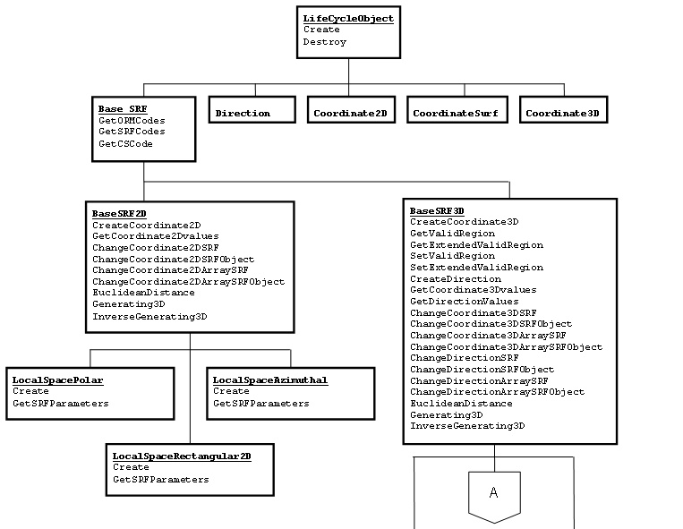
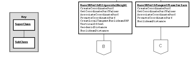
Figure 11.1 — Object inheritance hierarchy
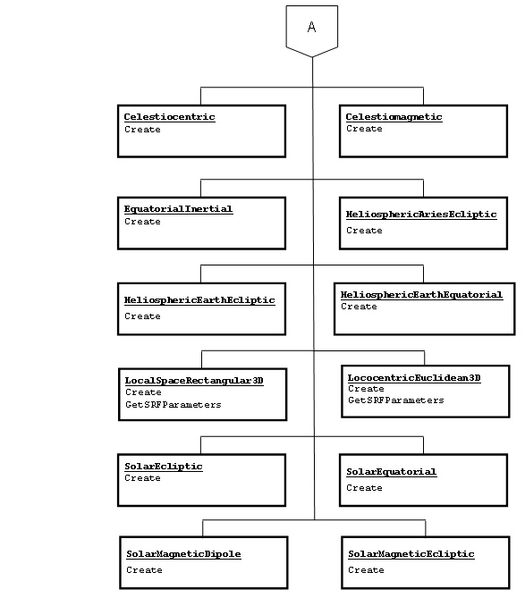
Figure 11.1 — Object inheritance hierarchy (continued)
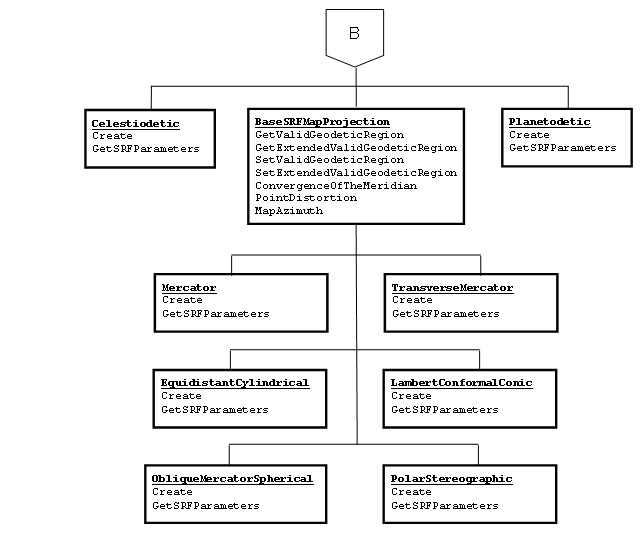
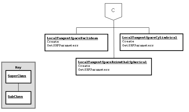
Figure 11.1 — Object inheritance hierarchy (continued)
11.8 Method precedence for life cycle objects and examples
There are restrictions on the order in which the methods of objects derived from LifeCycleObject may be invoked. The restrictions are:
a) The Create method (including subclassed versions) of a life cycle object shall be the first method invoked on any instance of the object.
b) The Destroy method (including subclassed versions) of a life cycle object shall be the last method invoked on any instance of the object. Depending on the language binding and the language capabilities, invocation of the destroy method may be:
1) explicit – invoked by the API user,
2) implicit – managed by the runtime system, or
3) implicit/optionally explicit – managed by the runtime system if not explicitly invoked by the API user on any single instance.
c) All other methods shall only be invoked after the Create method and before the Destroy method.
The following examples illustrate the method sequence for life cycle objects.
NOTE: The status for each invocation of a method or function should be checked for error conditions. For brevity and clarity this status checking is not shown in these examples.
EXAMPLE 1: Find the Euclidean distance between two locations.
--Note: Label in italics denotes a symbolic constant for this example -
Celestiodetic method Create(ORM_N_AM_1983, RT_N_AM_1983_CONUS; Output: ex1_srf)
ex1_srf method
CreateCoordinate3D( Inputs: -77º(π/180º), +38º(
π/180º),
0;
Output: coordinate1)
ex1_srf method
CreateCoordinate3D( Inputs +3º(
π/180º), +49º(
π/180º),
0;
Output: coordinate2)
ex1_srf method
EuclideanDistance( Inputs coordinate1, coordinate2;
Output: distance)
-- use distance result --
coordinate1 method destroy
coordinate2 method destroy
ex1_srf method
destroy
EXAMPLE 2: Change SRF representation of a location from UTM to Celestiocentric
--Note: Labels in italics denote symbolic constants for this example --
Function
CreateSRFSetMember
( Inputs: ( SRFS_UNIVERSAL_TRANSVERSE_MERCATOR,
SRFSM_ZONE_23_NORTHERN_HEMISPHERE
),
ORM_N_AM_1983,
RT_N_AM_1983_CONUS,
Output: source_srf)
source_srf method CreateCoordinate3D( Inputs: 350000, 400, 0,
Output: source_coordinate)
Function CreateStandardSRF( Inputs: SRF_GEOCENTRIC_WGS_1984,
RT_WGS_1984_IDENTITY,
Output: target_srf)
target_srf method
ChangeCoordinate3DSRF( Inputs: source_srf, source_coordinate,
Outputs: target_coordinate, region)
-- check region value and use result --
source_coordinate method destroy
target_coordinate method destroy
source_srf method destroy
target_srf method destroy
11.9 Data storage structures
11.9.1 Introduction
The data storage structures specify the exact ordering sequence and size of the information for persistent storage in any mass storage media. These structures are defined within this International Standard for applications that store SRM data and are not used with API methods or functions defined in this International Standard.
11.9.2 SRFT_Parameters
This non-object data type specifies the parameters for an arbitrary SRF template.
SRFT_Parameters ::= ( template_code SRFT_Code )
{
orm_code ORM_Code;
[
CELESTIOCENTRIC:
cc_srf_parameters <empty>;
LOCAL_SPACE_RECTANGULAR_3D:
lsr_3d_srf_parameters LSR_3D_Parameters;
CELESTIODETIC:
cd_srf_parameters <empty>;
PLANETODETIC:
pd_srf_parameters <empty>;
LOCAL_TANGENT_SPACE_EUCLIDEAN:
ltse_srf_parameters LTSE_Parameters;
LOCAL_TANGENT_SPACE_AZIMUTHAL_SPHERICAL:
ltsas_srf_parameters Local_Tangent_Parameters;
LOCAL_TANGENT_SPACE_CYLINDRICAL:
ltsc_srf_parameters Local_Tangent_Parameters;
LOCOCENTRIC_EUCLIDEAN_3D:
lce_3d_srf_parameters LCE_3D_Parameters;
CELESTIOMAGNETIC:
cm_srf_parameters <empty>;
EQUATORIAL_INERTIAL:
ei_srf_parameters <empty>;
SOLAR_ECLIPTIC:
sec_srf_parameters <empty>;
SOLAR_EQUATORIAL:
seq_srf_parameters <empty>;
SOLAR_MAGNETIC_ECLIPTIC:
sme_srf_parameters <empty>;
SOLAR_MAGNETIC_DIPOLE:
smd_srf_parameters <empty>;
HELIOSPHERIC_ARIES_ECLIPTIC:
haec_srf_parameters <empty>;
HELIOSPHERIC_EARTH_ECLIPTIC:
heec_srf_parameters <empty>;
HELIOSPHERIC_EARTH_EQUATORIAL:
heeq_srf_parameters <empty>;
MERCATOR:
m_srf_parameters M_Parameters;
OBLIQUE_MERCATOR_SPHERICAL:
oms_srf_parameters Oblique_Mercator_Parameters;
TRANSVERSE_MERCATOR:
tm_srf_parameters TM_Parameters;
LAMBERT_CONFORMAL_CONIC:
lcc_srf_parameters LCC_Parameters;
POLAR_STEREOGRAPHIC:
ps_srf_parameters PS_Parameters;
EQUIDISTANT_CYLINDRICAL:
ec_srf_parameters EC_Parameters;
LOCAL_SPACE_RECTANGULAR_2D:
lsr_2d_srf_parameters LSR_2D_Parameters;
LOCAL_SPACE_AZIMUTHAL:
lsa_srf_parameters <empty>;
LOCAL_SPACE_POLAR:
lsp_srf_parameters <empty>;
]
}
11.9.3 SRFS_Info
This non-object data type specifies the parameters for an arbitrary SRF set.
SRFS_Info ::= {
orm_code ORM_Code;
srfs_code_info SRFS_Code_Info;
}
11.9.4 SRF_Parameters_Info_Code
This non-object selection data type specifies an SRF code type.
SRF_Parameters_Info_Code ::= ( < 1 : // implementation dependent,
1 : TEMPLATE,
2 : SET,
3 : INSTANCE,
> 3 : // reserved for registration )
11.9.5 SRF_Parameters_Info
This non-object data type specifies the parameters for an arbitrary SRF, SRF set or SRF template.
SRF_Parameters_Info ::= ( srf_parameters_info_code SRF_Parameters_Info_Code )
{
rt_code RT_Code;
[TEMPLATE: srf_template SRFT_Parameters;
SET: srf_set SRFS_Info;
INSTANCE: srf_instance SRF_Code;
]
}
11.9.6 SRF_Reference_Surface_Info
This non-object data type specifies the information for an arbitrary SRF with its associated DSS information.
SRF_Reference_Surface_Info ::= {
dss_code DSS_Code;
srf_parameters_info SRF_Parameters_Info;
}
11.9.7 Coordinate structures
Structures are defined to store the specific values of a coordinate.
11.9.7.1 CD_3D_Coordinate
This non-object data type specifies the 3D coordinate components for SRFT CELESTIODETIC.
CD_3D_Coordinate ::= {
longitude Long_Float;
latitude Long_Float;
ellipsoidal_height Long_Float;
}
11.9.7.2 CD_Surface_Coordinate
This non-object data type specifies the surface coordinate components for SRFT CELESTIOCENTRIC.
CD_Surface_Coordinate ::= {
longitude Long_Float;
latitude Long_Float;
}
11.9.7.3 EI_3D_Coordinate
This non-object data type specifies the 3D coordinate components for SRFT EQUATORIAL_INERTIAL.
EI_3D_Coordinate ::= {
right_ascension Long_Float;
declination Long_Float;
radius Long_Float;
}
11.9.7.4 Euclidean_2D_Coordinate
This non-object data type specifies the 2D coordinate components for Euclidean space SRFTs.
Euclidean_2D_Coordinate ::= {
u Long_Float;
v Long_Float;
}
11.9.7.5 Euclidean_3D_Coordinate
This non-object data type specifies the 3D coordinate components for Euclidean space SRFTs.
Euclidean_3D_Coordinate ::= {
u Long_Float;
v Long_Float;
w Long_Float;
}
11.9.7.6 LSA_2D_Coordinate
This non-object data type specifies the 2D coordinate components for SRFT LOCAL_SPACE_AZIMUTHAL_2D.
LSA_2D_Coordinate ::= {
azimuth Long_Float;
radius Long_Float;
}
11.9.7.7 LSP_2D_Coordinate
This non-object data type specifies the surface coordinate components for SRFT LOCAL_SPACE_POLAR_2D.
LSP_2D_Coordinate ::= {
angle Long_Float;
radius Long_Float;
}
11.9.7.8 LTSAS_3D_Coordinate
This non-object data type specifies the 3D coordinate components for SRFT LOCAL_TANGENT_SPACE_AZIMUTHAL_SPHERICAL.
LTSAS_3D_Coordinate ::= {
azimuth Long_Float;
angle Long_Float;
radius Long_Float;
}
11.9.7.9 LTSAS_Surface_Coordinate
This non-object data type specifies the surface coordinate components for SRFT LOCAL_TANGENT_SPACE_AZIMUTHAL_SPHERICAL.
LTSAS_Surface_Coordinate ::= {
azimuth Long_Float;
angle Long_Float;
}
11.9.7.10 LTSC_3D_Coordinate
This non-object data type specifies the 3D coordinate components for SRFT LOCAL_TANGENT_SPACE_CYLINDRICAL.
LTSC_3D_Coordinate ::= {
angle Long_Float;
radius Long_Float;
height Long_Float;
}
11.9.7.11 LTSC_Surface_Coordinate
This non-object data type specifies the surface coordinate components for SRFT LOCAL_TANGENT_SPACE_CYLINDRICAL.
LTSC_Surface_Coordinate ::= {
angle Long_Float;
radius Long_Float;
}
11.9.7.12 LTSE_3D_Coordinate
This non-object data type specifies the 3D coordinate components for SRFT LOCAL_TANGENT_SPACE_EUCLIDEAN.
LTSE_3D_Coordinate ::= {
x Long_Float;
y Long_Float;
height Long_Float;
}
11.9.7.13 LTSE_Surface_Coordinate
This non-object data type specifies the surface coordinate components for SRFT LOCAL_TANGENT_SPACE_EUCLIDEAN.
LTSE_Surface_Coordinate ::= {
x Long_Float;
y Long_Float;
}
11.9.7.14 Map_Projection_3D_Coordinate
This non-object data type specifies the 3D coordinate components for map projection SRFTs.
Map_Projection_3D_Coordinate ::= {
easting Long_Float;
northing Long_Float;
ellipsoidal_height Long_Float;
}
11.9.7.15 Map_Projection_Surface_Coordinate
This non-object data type specifies the surface coordinate components for map projection SRFTs.
Map_Projection_Surface_Coordinate ::= {
easting Long_Float;
northing Long_Float;
}
11.9.7.16 Spherical_3D_Coordinate
This non-object data type specifies the 3D coordinate components for spherical SRFTs.
Spherical_3D_Coordinate ::= {
longitude Long_Float;
latitude Long_Float;
radius Long_Float;
}
11.9.8 Spatial_Coordinate_Code
This non-object selection data type specifies the spatial coordinate type.
Spatial_Coordinate_Code ::= ( < 1 : // implementation dependent,
1 : CC_3D,
2 : CD_3D,
3 : CD_SURFACE,
4 : CM_3D,
5 : EC_AUGMENTED_3D,
6 : EC_SURFACE,
7 : EI_3D,
8 : HAEC_3D,
9 : HEEC_3D,
10 : HEEQ_3D,
11 : LCC_AUGMENTED_3D,
12 : LCC_SURFACE,
13 : LCE_3D,
14 : LSA_2D,
15 : LSP_2D,
16 : LSR_2D,
17 : LSR_3D,
18 : LTSAS_3D,
19 : LTSAS_SURFACE,
20 : LTSC_3D,
21 : LTSC_SURFACE,
22 : LTSE_3D,
23 : LTSE_SURFACE,
24 : M_AUGMENTED_3D,
25 : M_SURFACE,
26 : OMS_AUGMENTED_3D,
27 : OMS_SURFACE,
28 : PD_3D,
29 : PD_SURFACE,
30 : PS_AUGMENTED_3D,
31 : PS_SURFACE,
32 : SEC_3D,
33 : SEQ_3D,
34 : SMD_3D,
35 : SME_3D,
36 : TM_AUGMENTED_3D,
37 : TM_SURFACE,
> 37 : // reserved for registration )
11.9.9 Coordinate
This non-object data type stores one of the defined coordinate.
Coordinate ::= ( spatial_coord_code Spatial_Coordinate_Code )
{
[ CC_3D: cc_3d Euclidean_3D_Coordinate;
CD_3D: cd_3d CD_3D_Coordinate;
CD_SURFACE: cd_surface CD_Surface_Coordinate;
CM_3D: cm_3d Spherical_3D_Coordinate;
EC_AUGMENTED_3D: ec_aug_3d Map_Projection_3D_Coordinate;
EC_SURFACE: ec_surface Map_Projection_Surface_Coordinate;
EI_3D: ei_3d Equatorial_Inertial_3D_Coordinate;
HAEC_3D: haec_3d Spherical_3D_Coordinate;
HEEC_3D: heec_3d Spherical_3D_Coordinate;
HEEQ_3D heeq_3d Spherical_3D_Coordinate;
LCC_AUGMENTED_3D lcc_aug_3d Map_Projection_3D_Coordinate;
LCC_SURFACE: lcc_surface Map_Projection_Surface_Coordinate;
LCE_3D: lce_3d Euclidean_3D_Coordinate;
LSA_2D: lsa_2d LSA_2D_Coordinate;
LSP_2D: lsp_2d LSP_2D_Coordinate;
LSR_2D: lsr_2d Euclidean_2D_Coordinate;
LSR_3D: lsr_3d Euclidean_3D_Coordinate;
LTSAS_3D: ltsas_3d LTSAS_3D_Coordinate;
LTSAS_SURFACE: ltsas_surface LTSAS_Surface_Coordinate;
LTSC_3D: ltsc_3d LTSC_3D_Coordinate;
LTSC_SURFACE: ltsc_surface LTSC_Surface_Coordinate;
LTSE_3D: ltse_3d LTSE_3D_Coordinate;
LTSE_SURFACE: ltse_surface LTSE_Surface_Coordinate;
MERCATOR_AUGMENTED_3D: m_aug_3d Map_Projection_3D_Coordinate;
MERCATOR_SURFACE: m_surface Map_Projection_Surface_Coordinate;
OMS_AUGMENTED_3D: oms_aug_3d Map_Projection_3D_Coordinate;
OMS_SURFACE: oms_surface Map_Projection_Surface_Coordinate;
PD_3D: pd_3d CD_3D_Coordinate;
PD_SURFACE: pd_surface CD_Surface_Coordinate;
PS_AUGMENTED_3D: ps_aug_3d Map_Projection_3D_Coordinate;
PS_SURFACE: ps_surface Map_Projection_Surface_Coordinate;
SEC_3D: sec_3d Spherical_3D_Coordinate;
SEQ_3D: seq_3d Spherical_3D_Coordinate;
SMD_3D: smd_3d Spherical_3D_Coordinate;
SME_3D: sme_3d Spherical_3D_Coordinate;
TM_AUGMENTED_3D: tm_aug_3d Map_Projection_3D_Coordinate;
TM_SURFACE: tm_surface Map_Projection_Surface_Coordinate;
]
}
11.9.10 RD_Code
RD_Code is a Selection data type (see 11.2.6). RD_Code specifies the RD code associated with a specified RD as defined in Clause 7. Table 7.3 is a directory of RD specifications, each of which includes a code value and a corresponding label. In the API, a standard or registered RD is represented by its RD code.
11.9.11 OBRS_Code
OBRS_Code is a Selection data type (see 11.2.6). OBRS_Code specifies an OBRS code defined in Clause 7. Table 7.18 is a directory of OBRS specifications, each of which includes a code value and a corresponding label. An OBRS is an SRM concept that is not directly used in the functional API.